WP_Query Object
(
[query] => Array
(
[paged] => 6
)
[query_vars] => Array
(
[paged] => 6
[error] =>
[m] =>
[p] => 0
[post_parent] =>
[subpost] =>
[subpost_id] =>
[attachment] =>
[attachment_id] => 0
[name] =>
[pagename] =>
[page_id] => 0
[second] =>
[minute] =>
[hour] =>
[day] => 0
[monthnum] => 0
[year] => 0
[w] => 0
[category_name] =>
[tag] =>
[cat] =>
[tag_id] =>
[author] =>
[author_name] =>
[feed] =>
[tb] =>
[meta_key] =>
[meta_value] =>
[preview] =>
[s] =>
[sentence] =>
[title] =>
[fields] =>
[menu_order] =>
[embed] =>
[category__in] => Array
(
)
[category__not_in] => Array
(
)
[category__and] => Array
(
)
[post__in] => Array
(
)
[post__not_in] => Array
(
)
[post_name__in] => Array
(
)
[tag__in] => Array
(
)
[tag__not_in] => Array
(
)
[tag__and] => Array
(
)
[tag_slug__in] => Array
(
)
[tag_slug__and] => Array
(
)
[post_parent__in] => Array
(
)
[post_parent__not_in] => Array
(
)
[author__in] => Array
(
)
[author__not_in] => Array
(
)
[suppress_filters] =>
[ignore_sticky_posts] =>
[cache_results] => 1
[update_post_term_cache] => 1
[lazy_load_term_meta] => 1
[update_post_meta_cache] => 1
[post_type] =>
[posts_per_page] => 15
[nopaging] =>
[comments_per_page] => 50
[no_found_rows] =>
[order] => DESC
)
[tax_query] => WP_Tax_Query Object
(
[queries] => Array
(
)
[relation] => AND
[table_aliases:protected] => Array
(
)
[queried_terms] => Array
(
)
[primary_table] => wp_posts
[primary_id_column] => ID
)
[meta_query] => WP_Meta_Query Object
(
[queries] => Array
(
)
[relation] =>
[meta_table] =>
[meta_id_column] =>
[primary_table] =>
[primary_id_column] =>
[table_aliases:protected] => Array
(
)
[clauses:protected] => Array
(
)
[has_or_relation:protected] =>
)
[date_query] =>
[queried_object] =>
[queried_object_id] =>
[request] => SELECT SQL_CALC_FOUND_ROWS wp_posts.ID FROM wp_posts WHERE 1=1 AND wp_posts.post_type = 'post' AND (wp_posts.post_status = 'publish') ORDER BY wp_posts.post_date DESC LIMIT 75, 15
[posts] => Array
(
[0] => WP_Post Object
(
[ID] => 1461
[post_author] => 2
[post_date] => 2018-08-26 12:24:10
[post_date_gmt] => 2018-08-26 12:24:10
[post_content] =>
Sorry, this entry is only available in Hungarian.
[post_title] => (Magyar) Megjelent a BORBAS projekt 2012-2017 évi kutatásait bemutató könyvünk
[post_excerpt] =>
[post_status] => publish
[comment_status] => open
[ping_status] => open
[post_password] =>
[post_name] => megjelent-a-borbas-projekt-2012-2017-evi-kutatasait-bemutato-projekt
[to_ping] =>
[pinged] =>
[post_modified] => 2018-08-26 12:33:39
[post_modified_gmt] => 2018-08-26 12:33:39
[post_content_filtered] =>
[post_parent] => 0
[guid] => http://bronzkor.hu/?p=1461
[menu_order] => 0
[post_type] => post
[post_mime_type] =>
[comment_count] => 0
[filter] => raw
[post_title_ml] => [:hu]Megjelent a BORBAS projekt 2012-2017 évi kutatásait bemutató könyvünk[:]
[post_title_langs] => Array
(
[hu] => 1
)
)
[1] => WP_Post Object
(
[ID] => 1451
[post_author] => 2
[post_date] => 2018-06-11 17:07:19
[post_date_gmt] => 2018-06-11 17:07:19
[post_content] =>
Sorry, this entry is only available in Hungarian.
[post_title] => (Magyar) Bronzkoros nemzetközi konferencia a Miskolci Egyetemen
[post_excerpt] =>
[post_status] => publish
[comment_status] => open
[ping_status] => open
[post_password] =>
[post_name] => bronzkoros-nemzetkozi-konferencia-a-miskolci-egyetemen
[to_ping] =>
[pinged] =>
[post_modified] => 2018-06-11 17:07:19
[post_modified_gmt] => 2018-06-11 17:07:19
[post_content_filtered] =>
[post_parent] => 0
[guid] => http://bronzkor.hu/?p=1451
[menu_order] => 0
[post_type] => post
[post_mime_type] =>
[comment_count] => 0
[filter] => raw
[post_title_ml] => [:hu]Bronzkoros nemzetközi konferencia a Miskolci Egyetemen[:]
[post_title_langs] => Array
(
[hu] => 1
)
)
[2] => WP_Post Object
(
[ID] => 1446
[post_author] => 2
[post_date] => 2018-05-27 08:44:28
[post_date_gmt] => 2018-05-27 08:44:28
[post_content] =>
Sorry, this entry is only available in Hungarian.
[post_title] => (Magyar) Új füzesabonyi temető Encs határában
[post_excerpt] =>
[post_status] => publish
[comment_status] => open
[ping_status] => open
[post_password] =>
[post_name] => uj-fuzesabonyi-temeto-encs-hataraban
[to_ping] =>
[pinged] =>
[post_modified] => 2018-05-27 08:49:11
[post_modified_gmt] => 2018-05-27 08:49:11
[post_content_filtered] =>
[post_parent] => 0
[guid] => http://bronzkor.hu/?p=1446
[menu_order] => 0
[post_type] => post
[post_mime_type] =>
[comment_count] => 0
[filter] => raw
[post_title_ml] => [:hu]Új füzesabonyi temető Encs határában[:]
[post_title_langs] => Array
(
[hu] => 1
)
)
[3] => WP_Post Object
(
[ID] => 1430
[post_author] => 2
[post_date] => 2018-05-15 17:30:26
[post_date_gmt] => 2018-05-15 17:30:26
[post_content] =>
Sorry, this entry is only available in Hungarian.
[post_title] => (Magyar) A Miskolci Egyetem Régészeti Tanszékének tanásatásai: Nagyvisnyó-Verepce, Cserépfalu-Mésztető
[post_excerpt] =>
[post_status] => publish
[comment_status] => open
[ping_status] => open
[post_password] =>
[post_name] => a-miskolci-egyetem-regeszeti-tanszekenek-tanasatasai-nagyvisnyo-verepce-cserepfalu-meszteto
[to_ping] =>
[pinged] =>
[post_modified] => 2018-05-15 17:32:34
[post_modified_gmt] => 2018-05-15 17:32:34
[post_content_filtered] =>
[post_parent] => 0
[guid] => http://bronzkor.hu/?p=1430
[menu_order] => 0
[post_type] => post
[post_mime_type] =>
[comment_count] => 0
[filter] => raw
[post_title_ml] => [:hu]A Miskolci Egyetem Régészeti Tanszékének tanásatásai: Nagyvisnyó-Verepce, Cserépfalu-Mésztető[:]
[post_title_langs] => Array
(
[hu] => 1
)
)
[4] => WP_Post Object
(
[ID] => 1424
[post_author] => 2
[post_date] => 2018-05-15 13:45:16
[post_date_gmt] => 2018-05-15 13:45:16
[post_content] =>
Sorry, this entry is only available in Hungarian.
[post_title] => (Magyar) Régészt vagy Rendőrt? Földes nap a Miskolci Egyetemen
[post_excerpt] =>
[post_status] => publish
[comment_status] => open
[ping_status] => open
[post_password] =>
[post_name] => regeszt-vagy-rendort-foldes-nap-a-miskolci-egyetemen
[to_ping] =>
[pinged] =>
[post_modified] => 2018-05-15 13:45:16
[post_modified_gmt] => 2018-05-15 13:45:16
[post_content_filtered] =>
[post_parent] => 0
[guid] => http://bronzkor.hu/?p=1424
[menu_order] => 0
[post_type] => post
[post_mime_type] =>
[comment_count] => 0
[filter] => raw
[post_title_ml] => [:hu]Régészt vagy Rendőrt? Földes nap a Miskolci Egyetemen[:]
[post_title_langs] => Array
(
[hu] => 1
)
)
[5] => WP_Post Object
(
[ID] => 1400
[post_author] => 2
[post_date] => 2018-01-30 20:37:16
[post_date_gmt] => 2018-01-30 20:37:16
[post_content] =>
Sorry, this entry is only available in Hungarian.
[post_title] => (Magyar) Az abaújdevecseri "kartekercs"
[post_excerpt] =>
[post_status] => publish
[comment_status] => open
[ping_status] => open
[post_password] =>
[post_name] => az-abaujdevecseri-kartekercs
[to_ping] =>
[pinged] =>
[post_modified] => 2018-02-09 13:13:36
[post_modified_gmt] => 2018-02-09 13:13:36
[post_content_filtered] =>
[post_parent] => 0
[guid] => http://bronzkor.hu/?p=1400
[menu_order] => 0
[post_type] => post
[post_mime_type] =>
[comment_count] => 0
[filter] => raw
[post_title_ml] => [:hu]Az abaújdevecseri "kartekercs"[:]
[post_title_langs] => Array
(
[hu] => 1
)
)
[6] => WP_Post Object
(
[ID] => 1393
[post_author] => 2
[post_date] => 2018-01-28 19:06:48
[post_date_gmt] => 2018-01-28 19:06:48
[post_content] =>
Sorry, this entry is only available in Hungarian.
[post_title] => (Magyar) Új bronzkinccsel gyarapodott a Herman Ottó Múzeum
[post_excerpt] =>
[post_status] => publish
[comment_status] => open
[ping_status] => open
[post_password] =>
[post_name] => uj-bronzkinccsel-gyarapodott-a-herman-otto-muzeum
[to_ping] =>
[pinged] =>
[post_modified] => 2018-01-28 19:06:48
[post_modified_gmt] => 2018-01-28 19:06:48
[post_content_filtered] =>
[post_parent] => 0
[guid] => http://bronzkor.hu/?p=1393
[menu_order] => 0
[post_type] => post
[post_mime_type] =>
[comment_count] => 0
[filter] => raw
[post_title_ml] => [:hu]Új bronzkinccsel gyarapodott a Herman Ottó Múzeum[:]
[post_title_langs] => Array
(
[hu] => 1
)
)
[7] => WP_Post Object
(
[ID] => 1361
[post_author] => 2
[post_date] => 2018-01-21 18:34:49
[post_date_gmt] => 2018-01-21 18:34:49
[post_content] => You can download the volumes of Acta Archaeologica and Archaeologia Értesítő from the pages:
http://real-j.mtak.hu/view/journal/Acta_Archaeologica.html
http://real-j.mtak.hu/view/journal/Archaeologiai_Értesítő.html
In addition, all museum yearbooks and publications can be found in the following places by counties:
https://library.hungaricana.hu/hu/collection/magyar_muzeumi_digitalis_konyvtar/
Have a nice read and access to everyone!
[post_title] => Online archaeological literature from Hungary available
[post_excerpt] =>
[post_status] => publish
[comment_status] => open
[ping_status] => open
[post_password] =>
[post_name] => acta-archaeologica-es-archaeologia-ertesito-elerhetosegei
[to_ping] =>
[pinged] =>
[post_modified] => 2018-01-28 16:01:08
[post_modified_gmt] => 2018-01-28 16:01:08
[post_content_filtered] =>
[post_parent] => 0
[guid] => http://bronzkor.hu/?p=1361
[menu_order] => 0
[post_type] => post
[post_mime_type] =>
[comment_count] => 0
[filter] => raw
[post_title_ml] => [:hu]Acta Archaeologica és Archaeologia Értesítő elérhetőségei[:en]Online archaeological literature from Hungary available[:]
[post_title_langs] => Array
(
[hu] => 1
[en] => 1
)
)
[8] => WP_Post Object
(
[ID] => 1315
[post_author] => 2
[post_date] => 2018-01-16 18:35:00
[post_date_gmt] => 2018-01-16 18:35:00
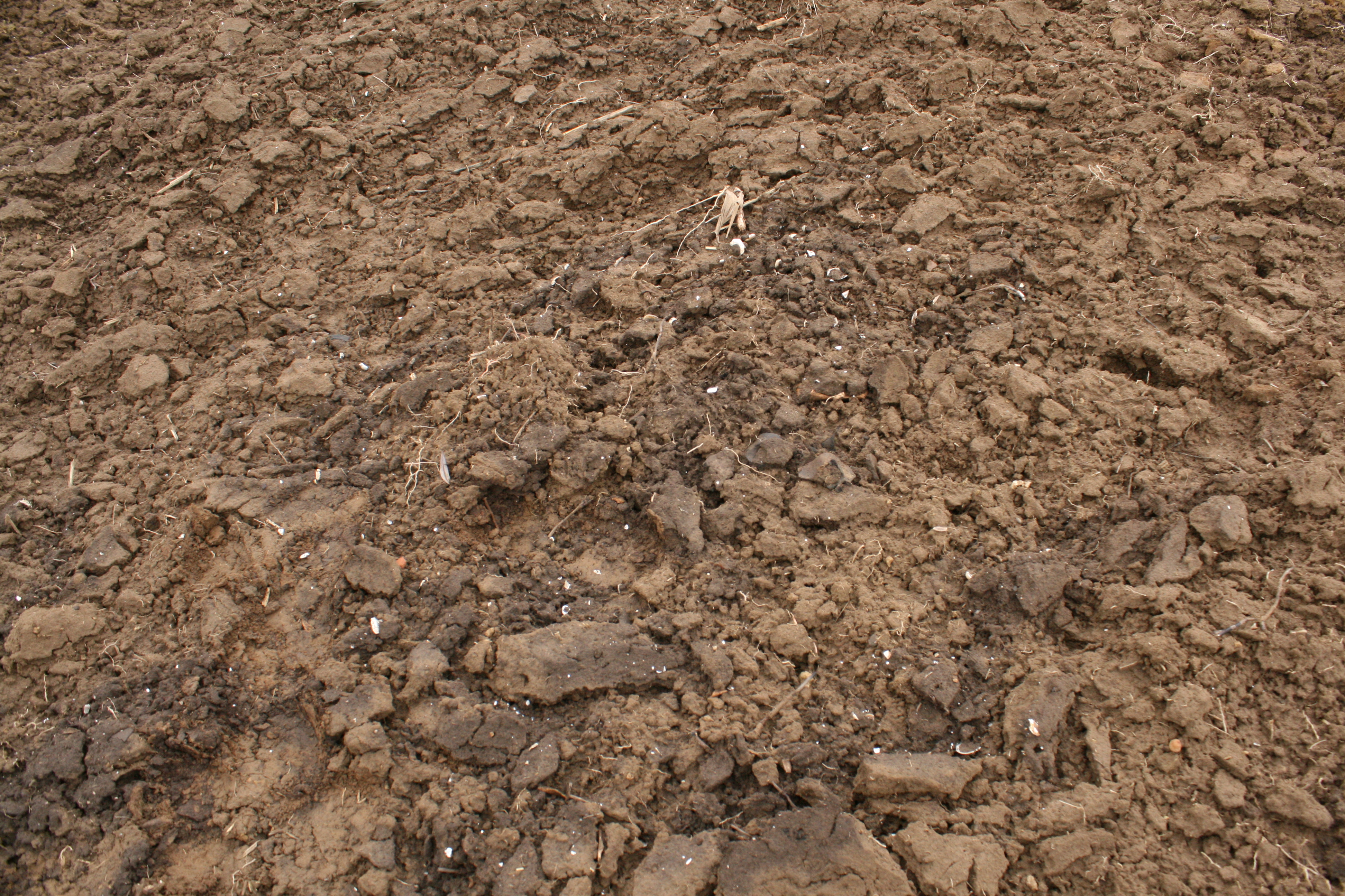
[post_content] => Elmesélem a szombati nap 3. nagy felfedezését. Vizsoly és Vilmány után Göncre vezetett utunk. Itt egy honfoglaló lelőhely azonosítását szerettük volna elvégezni, de lássatok csodát egy füzesabonyi telepet találtunk helyette. A göncruszkai pálinkafőzővel szemben indultunk a szántásban. Itt a Gönci patak mentén haladva meredeken fölénk emelkedett a patak magaspartja, melynek nyugati peremén fut közvetlenül a vasútvonal.

A meredek part csak egy helyen szántott, itt azonban egy általunk már jól ismert tulajdonságokkal jelentkező elszántott bronzkori gödröt találtunk. A gödör sötét színű betöltését a szántás már széthúzta, azonban a széttört fehér kagyló a gödör tartalmának szóródását jól mutatta. A leletanyagban tipikus füzesabonyi kerámiát találtunk.
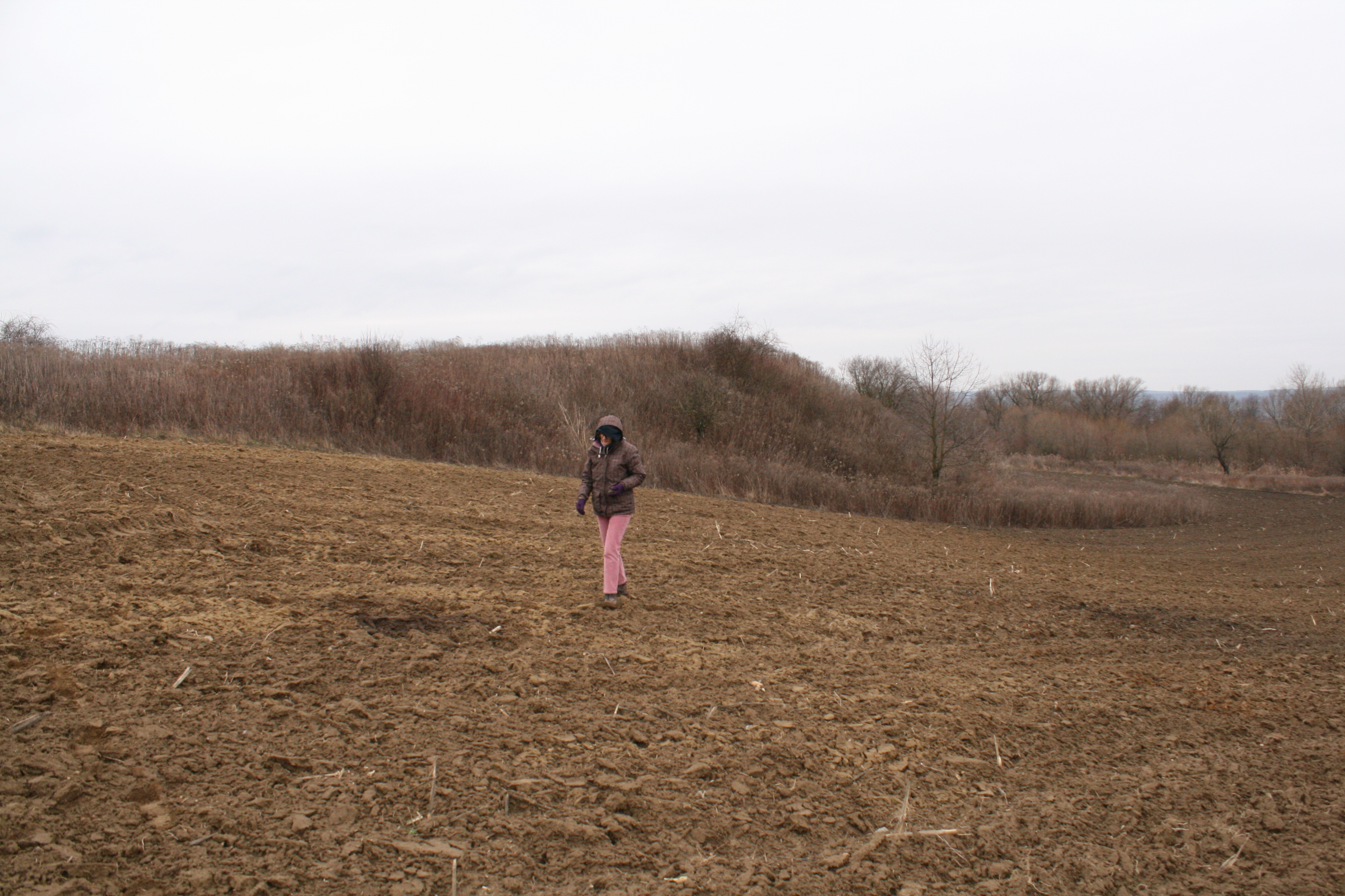
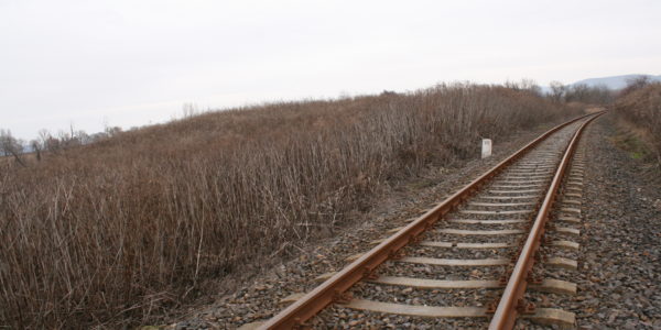
A gödröt lefotózva és felnézve a magaspartra egy jellegzetes promontor típusú kinyúlást láttunk. Na mondom, gyerünk, ott lesz a település központi része. Megmásztuk a magaspartot és a síneken haladva elértük a kívánt helyet, melyen embermagasságnál nagyobb kóró volt nagyon sűrűn.

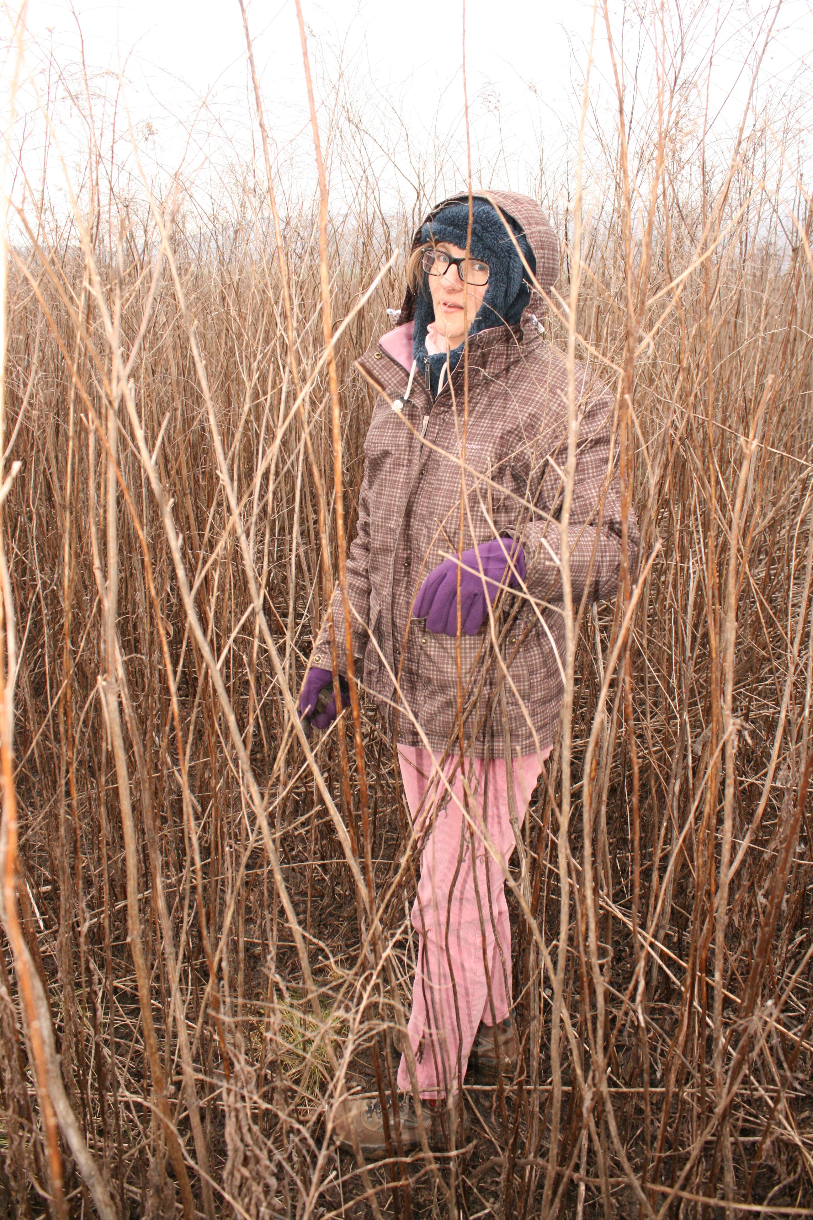
Gondolkodás nélkül vetettük be magunkat a rengetegbe és tényleg tele volt a felszín leletekkel. A terület keleti oldalán futó vasúti sínek mellett a 413-as kilométerkő áll, így a lelőhely a Gönc-Lúd dűlő, 413-as kilométerkő nevet kapta.
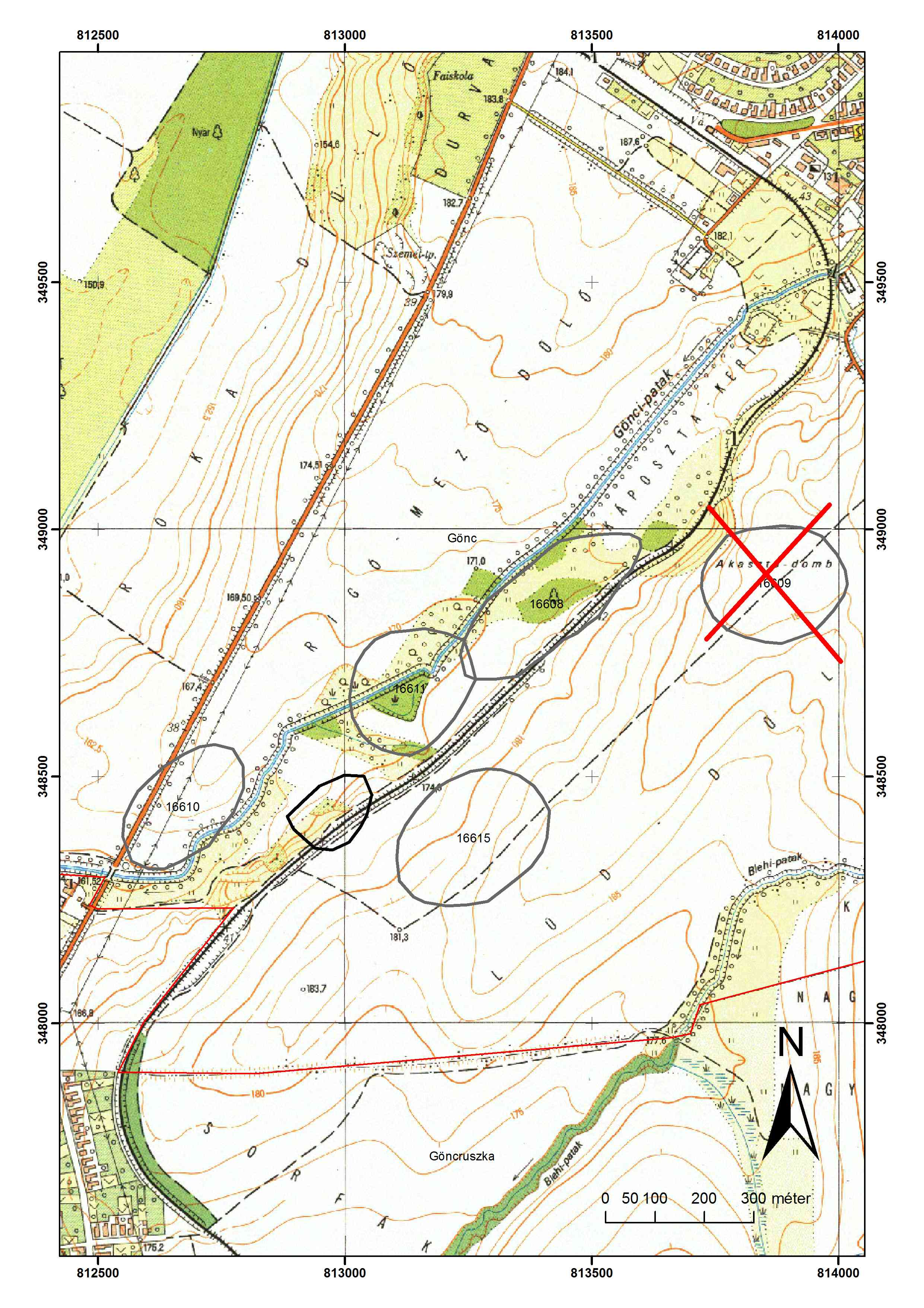
A történet azonban van tovább is. Hazatérve megnéztem a közhiteles adatbázist. Losits Ferenc 1979-ben bejárta a Gönci patak ezen partját és számos lelőhelyet detektált. Az adatbázis szerint az Akasztó dombon füzesabonyi települést talált. Az akasztó dombi poligon illetve a dűlőnév az EOV térképen északra található az általunk átvizsgált területtől. Mi elsősorban a patak völgytalpát kívántuk most megnézni, nem a magaspartot. A Herman Ottó múzeum adattárának (HOM RégAd.: 518-1981) digitális regesztájában talált leírás azonban megoldotta a rejtélyt. A Losits dokumentáció Gönc-akasztódombi része a következőket írja: Az Orosz-kúttól DNy-ra lévő, 177,8 magassági ponttal jelzett domb, amely 10-12 m szintkülönbséggel szakad le a patak felé. A domb teteje egy szintben van a vasúton túli területtel, attól csak a vasúti sínek részére mélyített, 2 m mély árok választja el. A kiemelkedésen, (felülete 20x20 m) és oldalában igen sok középső bronzkori /füzesabonyi kultúra/ cserép volt.
Vagyis az általunk megtalált lelőhely azonos Losits lelőhelyével, csak a dűlőnevek ismerete hiányában az Akasztó domb névadás miatt rossz helyen lett a közhiteles adatbázis térképi állományában jelölve.
A szombati napon nem bronzkori meglepetések is értek minket, de ezeket hagyom elmesélni másoknak. A bejegyzéseket végig többesszámban írtam, mivel a felfedező túrát Pusztai Tamással, a férjemmel tettük. Köszönöm neki ezt a szép napot!
[post_title] => A gönci vasútvonal titka
[post_excerpt] =>
[post_status] => publish
[comment_status] => open
[ping_status] => open
[post_password] =>
[post_name] => a-gonci-vasutvonal-titka
[to_ping] =>
[pinged] =>
[post_modified] => 2018-01-16 18:36:20
[post_modified_gmt] => 2018-01-16 18:36:20
[post_content_filtered] =>
[post_parent] => 0
[guid] => http://bronzkor.hu/?p=1315
[menu_order] => 0
[post_type] => post
[post_mime_type] =>
[comment_count] => 0
[filter] => raw
)
[9] => WP_Post Object
(
[ID] => 1298
[post_author] => 2
[post_date] => 2018-01-14 21:58:13
[post_date_gmt] => 2018-01-14 21:58:13
[post_content] => A blog egy ösztöndíj miatt indult. 2014-ben elnyertem a TÁMOP-4.2.4.A/2-11/1-2012-0001 Nemzeti Kiválóság Program című kiemelt projekt keretében a Szentágothai János tapasztalt kutatói ösztöndíjat. Így a Német állam Humboldt ösztöndíja (2008-2009) és a Szlovák állam National Scholarship Programja (2017-2018) között 2014 és 2015-ben a Magyar állam kutatói ösztöndíjasa is lehettem. A vállalható tevékenységek között szerepelt a tudományos blogírás is, gondoltam ez menni fog nekem is, bár korábban még nem csináltam. Aztán rájöttem, hogy nem is olyan egyszerű. Legyen rövid és közérthető egy bejegyzés, de szakmailag pontos, és irodalommal alátámasztott. Szóljon a bronzkorról, de ne legyen mindig ugyanaz a téma. Ráadásul nemcsak egy wordszöveget kell megírni, hanem be is kell szerkeszteni egy megfelelő felületre (ezer hála és köszönet a Pazirik Kft munkatársainak, akik a kezdés óta éjjel-nappal segítenek ebben). Szóval kell vele dolgozni, ha azt akarom jó legyen.
De megéri. Hiszen olvassák, megosztják, szólnak a kollégák, ha szakmai hiba van benne, hivatkozzák más régész fórumok, felhívnak idegenek, hogy elmeséljék mit találtak és még az oktatásban is hasznos lehet.
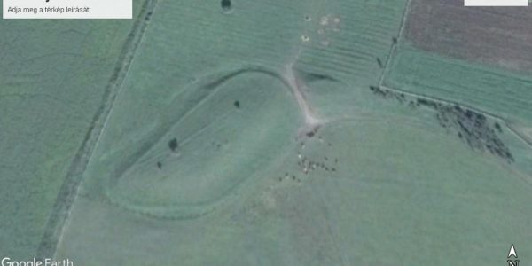
Így történt, hogy a szigetszerű lelőhelyekről szóló bejegyzés ismeretében Bodnár Tamás levéltáros barátunk szólt, hogy van egy hasonló tünemény Vilmány határában. Ajándékba kaptam a lelőhelyet csütörtökön és még kettőt kellett aludnom, hogy szombaton, 2018 január 13-án elindulhassunk megnézni. A Googleearth fotó alapján hinni se mertem, hogy létezik ilyen csoda és eddig senki sem tudott róla.
Pedig tudott. A megye régészeti lelőhelyeinek egyik legalaposabb ismerője Hellebrandt Magdolna bejárta és bejelentette 2003-ban. Azóta szerepel a közhiteles nyilvántartásban 37534-es számon mint koravaskori lelőhely.
A lelőhely a googleearth fotóján és a EOV térképen egy a Hernád első teraszáról kinyúló, mesterséges árokkal leválasztott és körbevett, markáns kiemelkedés. Első ránézésre egyértelműen tell. A földrajzi helyzet, a kialakítás, a térválasztás mind-mind a középső bronzkori füzesabonyi kultúrába sorolta a szememben. Mégis valami józan paraszti ész gátat szabott lelkesedésemnek. Majd megnézzük szombaton és akkor örülünk, gondoltam. Jártunk már így lelőhellyel (Onga-Nagy erdő (Kerek-domb), azon.: 32217), ami az összes eddigi tapasztalatunk alapján tipikus középső bronzkor volt, míg kint a helyszínen, természetes dombon (tökéletesen kör alakú volt) "csak" AVK, tiszadobi és bükki leletanyagot találtunk. Ez esetben utólag néztem meg, hogy az adatbázisban ismert neolit lelőhelyként van a terület nyilvántartva. Szóval okulva saját hibámból és látva a kora-vaskori keltezést igyekeztem józan maradni, bár a prekoncepciómba beleillett a nyaktaggal leválasztott "tell" külső telepeként felfogható 37535-ös azonosítójú lelőhely.
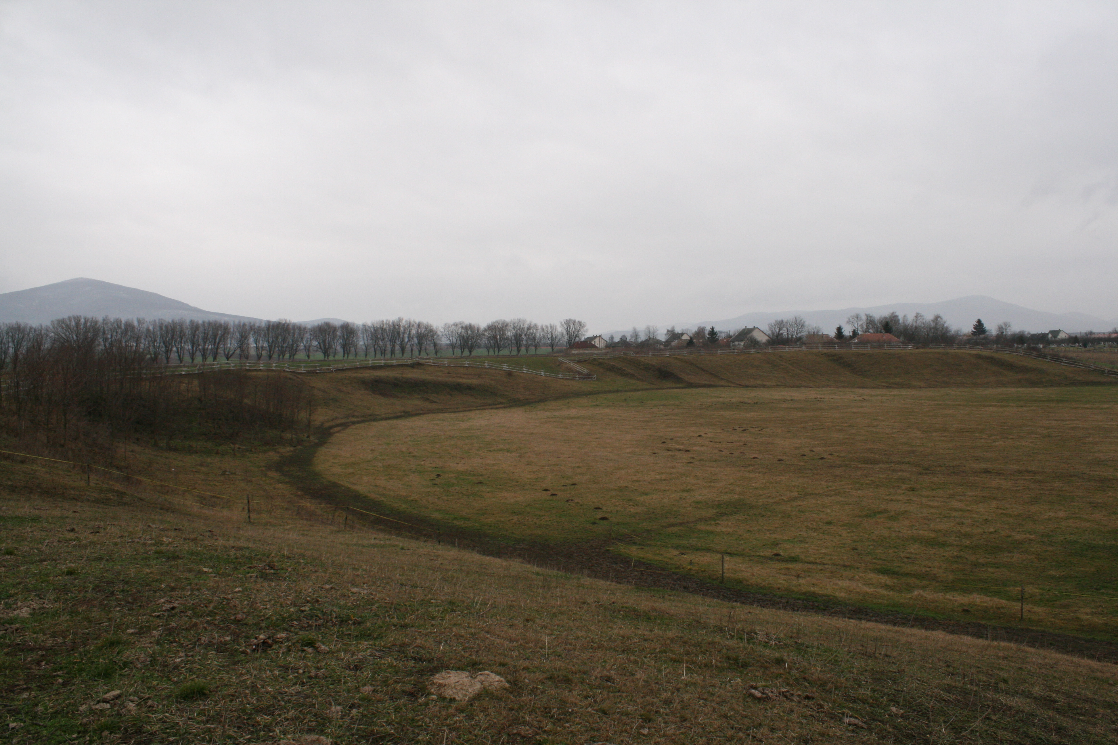
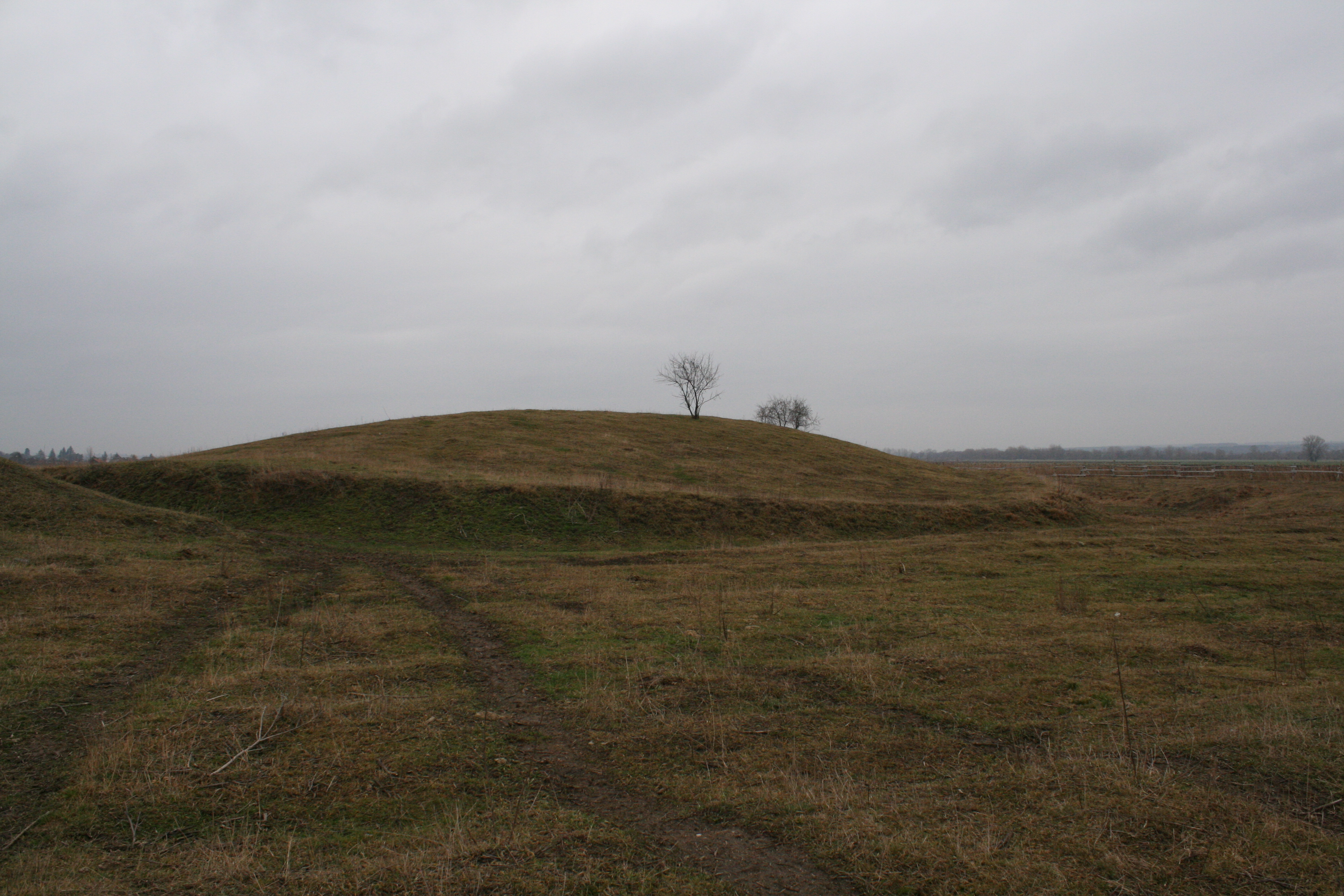
A helyszínre érve megdöbbentő látvány fogadott. A Hernád magaspartja itt szinte függőleges, a Kollár domból délre olyan félkörívet ír le, mintha mesterségesen lenne kialakítva. Lélegzetelállítóan gyönyörű. Bár a lélegzetemet a kocsiból kilépve az éles +1 fokos szél is elállította, sőt olyan könnyes lett a szemem, hogy az első körbejárásnál nem is igazán láttam a talajt.
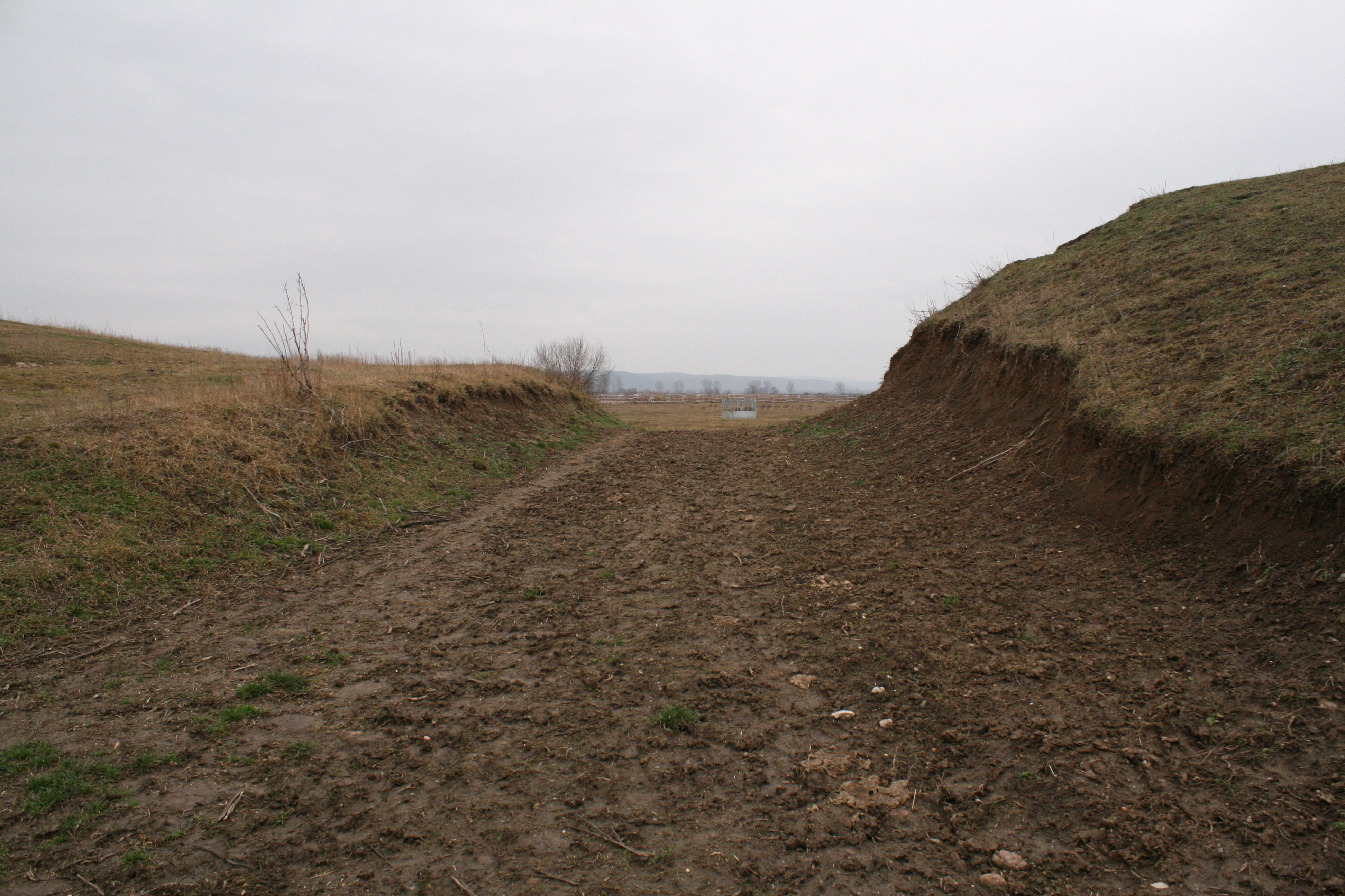
A terület legelő. Az űrfelvételen is látszó, állatok által is használt út az egykori árok további szélesítésével jött létre, vagyis nem szeli ketté a lelőhelyet, hanem amikor kiásták a ma is markánsan követhető árkot, az itt futott.
A domb tetején több nagy állatjárat (róka vagy borzvár) található. Megszoktuk ezt a telleknél, örültem is kicsit, mondván pár perc alatt több zacskó cserép és mehetünk haza pezsgőt bontani. A domb többszöri bejárása s az állatjáratok átvizsgálása után is azonban csak 4 db cserepet találtunk. Vastagfalú, durva általános őskori kerámiát. Az útbevágásban semmi jele rétegnek. A rókajáratokban úgyszintén egységes a talaj. A magasparton keletre a levágott domból a szántásban semmi lelet.
Vagyis van valami ember által nagy munkával körbeárkolt gyönyörű természeti forma, ami nem többrétegű, mesterséges halom. Lelőhely, mert a cserepek nem mennek oda maguktól, de csak időszakosan vagy rövid ideig használt területről lehet szó a mostani megfigyeléseink alapján. A kora pedig rejtély!
Volt már olyan tapasztalatom, hogy valamiről bizton állítottam, hogy középső bronzkori, mert viselem a középső bronzkori szemellenzőt és évekbe telt míg az adatok meggyőztek valószínűleg nem helyes a gondolkodásom (ez az abaújdevecseri kartekerccsel történt, holnap írok róla).
Vagyis Hellebrandt Magdolna aki egy időben későbronzkori-koravaskori "vizivárakat" keresett (Hellebrandt 2004), a pár jellegtelen cserép alapján ebbe a korszakba sorolta, én aki tellt keresek, nyilván a középső bronzkorba szeretném datálni, de egyik sem bizonyítható egyelőre.
Az az ötletem támadt, hogy nyáron csinálunk egy hétvégés "time team" munkát, amit le is filmezhetünk. Légifotó, geofizika, és a központi róka vagy borzvár kitakarítása, és metszetek készítése, datáló leletanyag keresése lenne a cél. Ha kint alszunk hálózsákokban a lelőhelyen -aminél szebbet elképzelni sem tudok - a sok szúnyogcsípésnél több bajunk nem lehet.

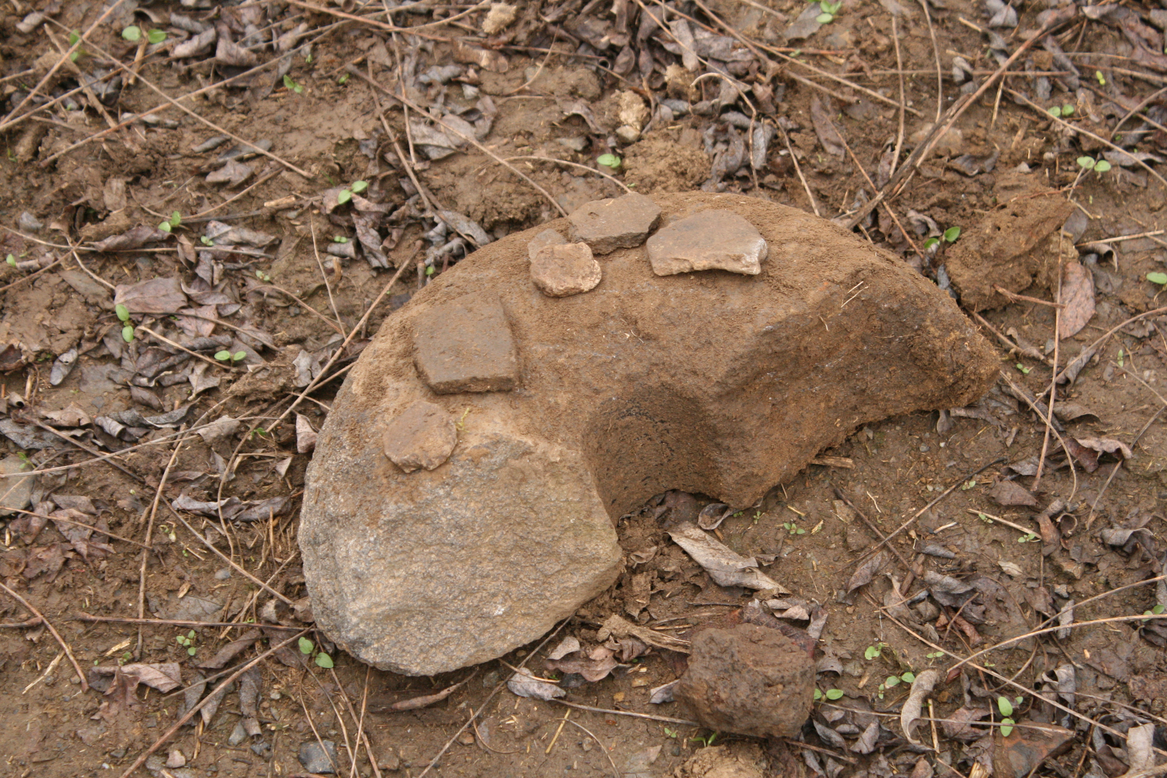
A lelőhelyről visszafelé jövet a földút bevágódásában pedig találtunk egy letapasztott platnit, mellette és felette a szántásban középkori cserepekkel és az út metszetéből kibontottam egy őrlőkövet. Vagyis 300 méterre délkeletre a tüneménytől biztosan van egy középkori település.
Hát majd meglátjuk.....
Mindenesetre köszönet a tippért és a csodás napért!
Irodalom:
Hellebrandt Magdolna: Őskori föld és vízivárak. Prehistoric Earthworks and Forts Surrounded by Bodies of Water. in: Nagy Emese Gyöngyvér - Dani János - Hajdú Zsigmond szerk.: MΩMOΣ II. Őskoros Kutatók II. Összejövetelének konferenciakötete. Debrecen, 2004b, 171–186.
[post_title] => Miért jó blogolni, avagy hogyan is jutottam el Vilmány-Kollár dombra
[post_excerpt] =>
[post_status] => publish
[comment_status] => open
[ping_status] => open
[post_password] =>
[post_name] => miert-jo-blogolni-avagy-hogyan-is-jutottam-el-vilmany-kollar-dombra
[to_ping] =>
[pinged] =>
[post_modified] => 2018-01-14 22:21:14
[post_modified_gmt] => 2018-01-14 22:21:14
[post_content_filtered] =>
[post_parent] => 0
[guid] => http://bronzkor.hu/?p=1298
[menu_order] => 0
[post_type] => post
[post_mime_type] =>
[comment_count] => 0
[filter] => raw
)
[10] => WP_Post Object
(
[ID] => 1278
[post_author] => 2
[post_date] => 2018-01-14 20:49:21
[post_date_gmt] => 2018-01-14 20:49:21
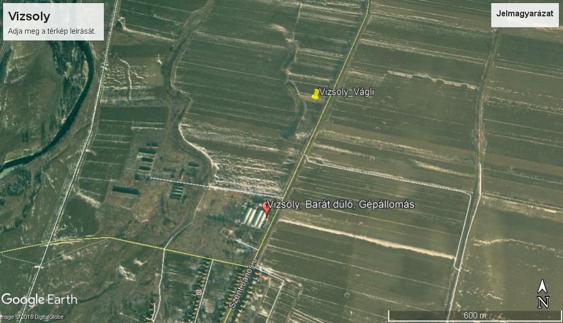
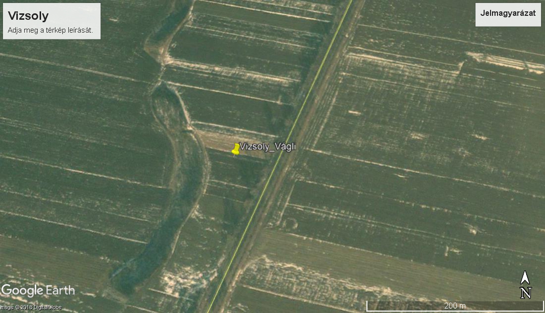
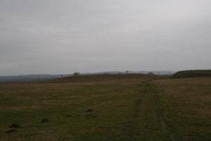
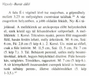
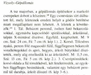
[post_content] => Koós Judit 1991-ben az Archaeológiai Értesítőben publikálta B-A-Z megye füzesabonyi temetkezéseit (Koós 1991). Mivel nagyobb temetőfeltárás a megyaszói és a hernádkaki jól ismert lelőhelyek óta nem történt a megyében, így a pubikációban több lelőhely szórványosan előkerült adatai kerültek összefoglalásra. Itt olvashatunk 2 sírról Vizsoly-Barát dűlő és Vizsoly-Gépállomás lelőhelyekkel. Ha a leírásokat elolvassuk egyértelművé válik, hogy a két sír egy azon lelőhely, egyazon temetőjéből kerülhetett elő, Vizsoly északi határában levő TSZ gépállomásának területéről.
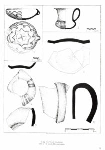
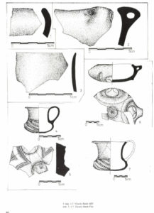
A Hernád völgyi füzesabonyi lelőhelyeket intenzívebben vizsgáló mostani kutatási szakaszban kísérletet tettünk a temető helyének ismeretében a temetkezési helyhez tartozó bronzkori település lokalizálására. Abból a tényből indulunk ki, hogy azon esetekben amikor a település és a temető helyét is ismerjük a temetkezési hely a településhez képest 1 km sugarú körön belül található (az adatokat lásd egy következő bejegyzésben), a topográfiai térképen próbáltunk az eddig megismert "füzesabonyi gondolkodásmóddal" egy megfelelő települési helyet keresni. Itt a Hernád első és második terasza jöhetett szóba. A második teraszon foglal helyet Hernádbüd-Várdomb (eddig igazolhatóan csak hatvani telep) és Felsődobsza-Várdomb is.
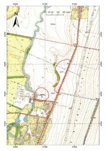
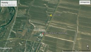
A közhiteles adatbázis adatait megnézve azonban a gépállomástól északra, az első teraszon a 150 tszf magassági vonalhoz igazodva egy bronzkori besorolású lelőhely található. Így azt az egyszerű megoldást követtük, hogy a terepen újra bejártuk a 90731 azonosítójú lelőhelyet, melynek topográfiai adatai valóban megfelelnek egy füzesabonyi típusú településnek. A bejárásra 2018 január 13-án, +1 fokban, szitáló hóesésben, erős szélben került sor. Ez a nap számos más bronzkori meglepetést is tartogatott számunkra a másnapra jelentkező megfázás tünetein kívül. Ezekről az elkövetkező napokban folyamatosan beszámolok.
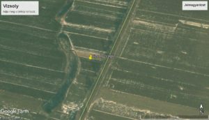
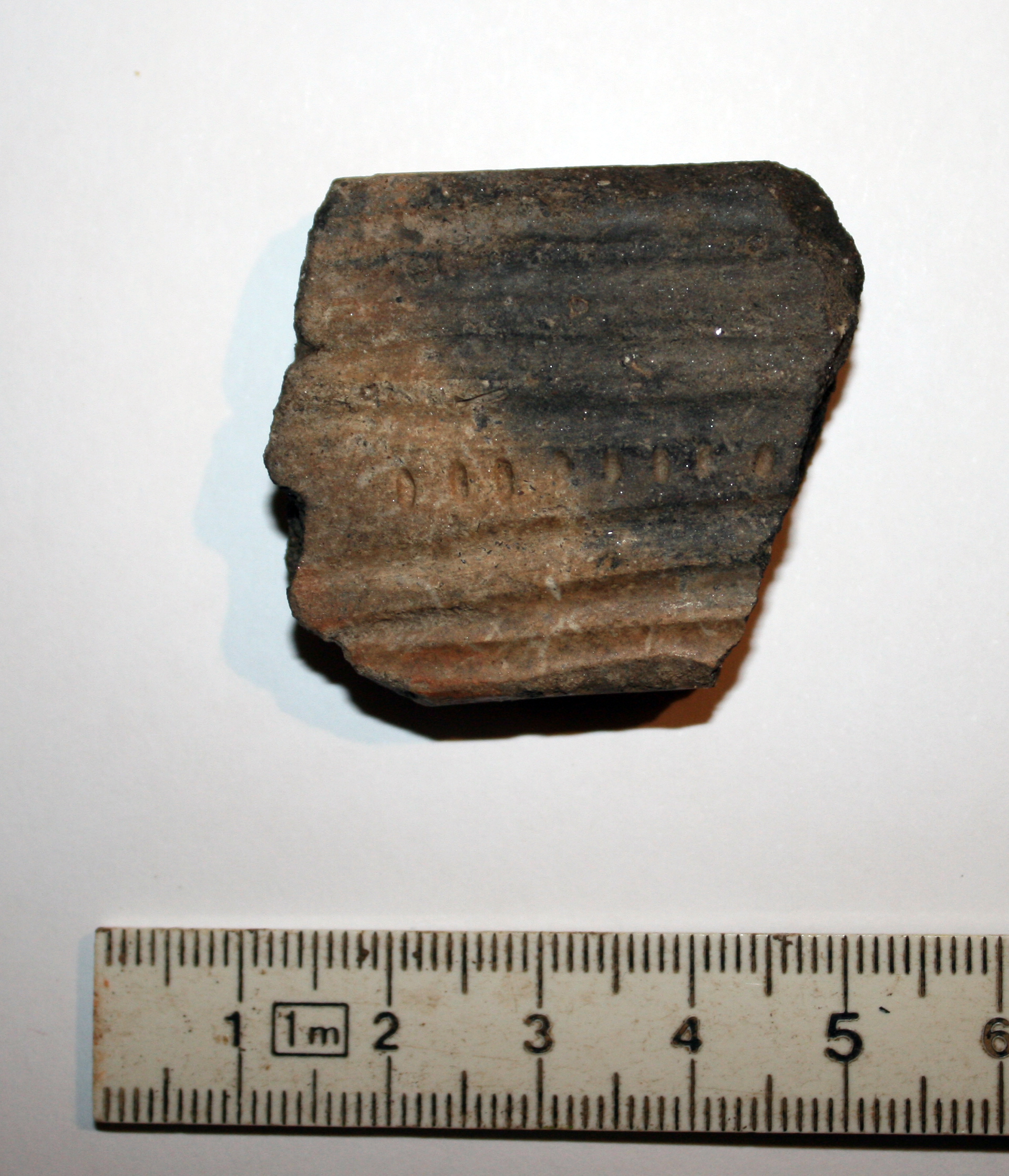
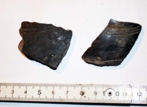
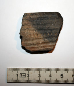
Vizsolyban a kissé promontorszerűen kiugró első teraszon ároknak felszíni nyomát nem érzékeltük. A felszínen középkori és népvándorláskori leletanyag mellett masszívan jött a bronzkor. A középső bronzkori, füzesabonyi datálást az alábbi töredék sokatmondóan támasztja alá.
Vagyis a Vizsoly-Gépállpmás (Barát dűlő) és Vizsoly-Vágli lelőhelyek egy egymástól kb. 500 méterre levő, markáns mélyedéssel elválasztott térszínek ismét ékes példáját mutatják annak, hogyha rendszerben gondolkodunk előbb-utóbb a helyükre kerülnek a kirakós darabjai.
Irodalom:
Koós Judit: A füzesabonyi kultúra sírjai Borsod megyében. – Die Spuren der Füzesabony-Kultur im Komitat Borsod. Archaeológiai Értesítő 118 (1991) 45–61.
[post_title] => Vizsoly nemcsak a Biblia miatt lehet fontos
[post_excerpt] =>
[post_status] => publish
[comment_status] => open
[ping_status] => open
[post_password] =>
[post_name] => vizsoly-nemcsak-a-biblia-miatt-lehet-fontos
[to_ping] =>
[pinged] =>
[post_modified] => 2018-01-14 20:51:28
[post_modified_gmt] => 2018-01-14 20:51:28
[post_content_filtered] =>
[post_parent] => 0
[guid] => http://bronzkor.hu/?p=1278
[menu_order] => 0
[post_type] => post
[post_mime_type] =>
[comment_count] => 0
[filter] => raw
)
[11] => WP_Post Object
(
[ID] => 1152
[post_author] => 2
[post_date] => 2018-01-04 20:30:46
[post_date_gmt] => 2018-01-04 20:30:46
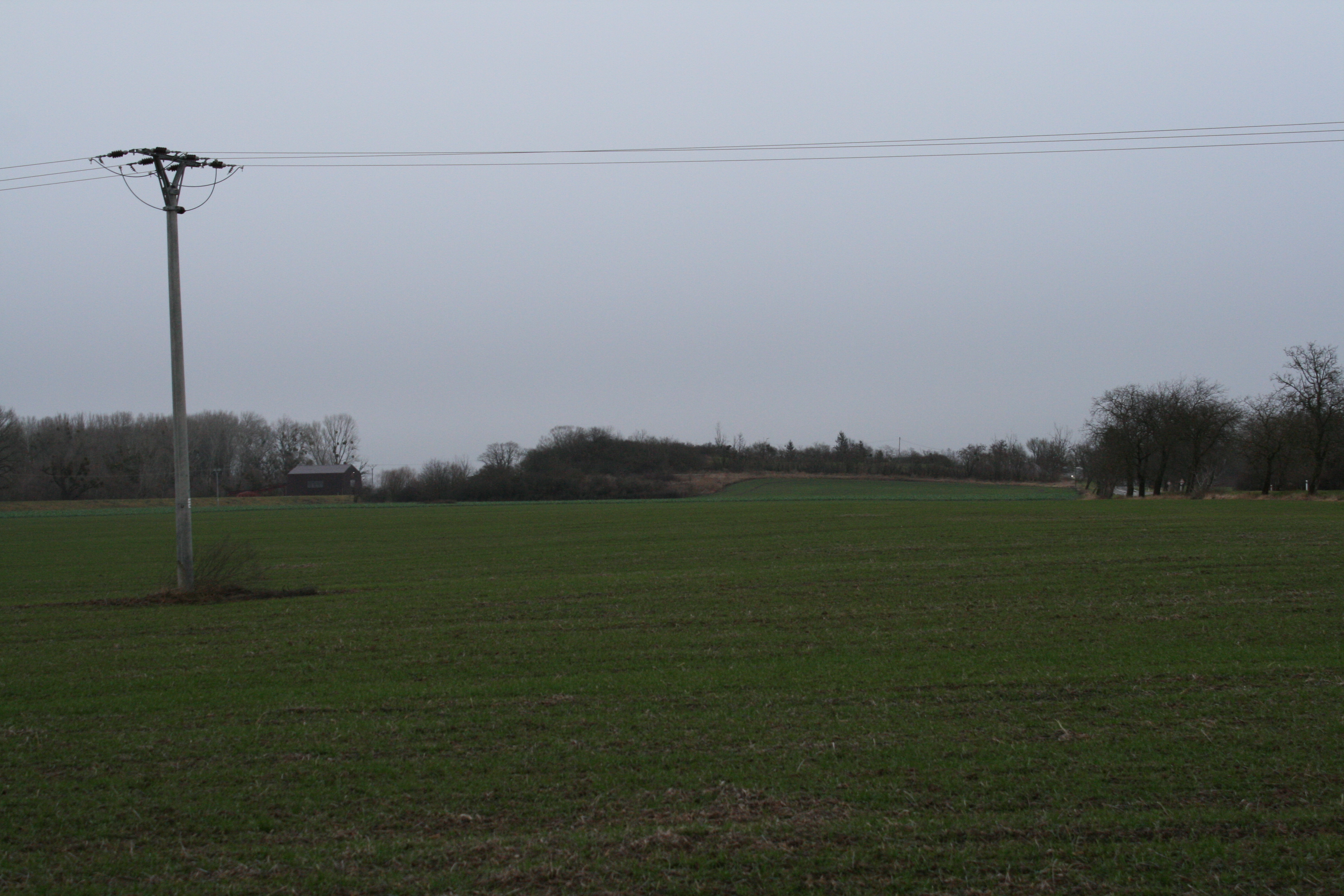
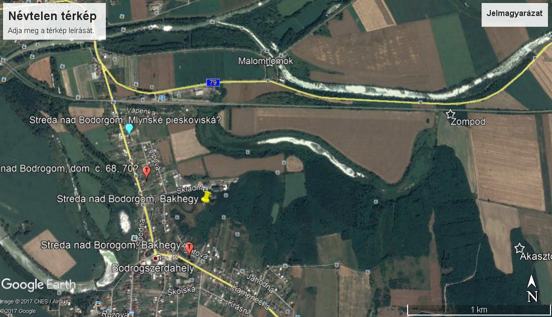
[post_content] => Bodrogszerdahely’s name is rather well-known in Bronze Age literature, since this is where the eponymous site of the Füzesabony culture’s late koszider period, a bi-ritual cemetery, came to light (Polla 1960). However it is a lesser known fact that multiple sites from that same timeframe also exist at the edge of the settlement. We made an effort to localize these sites and clear up the confusion regarding their names on December 29, 2017. Naturally the field survey was preceded by plenty of research, the results of which you can read about here.
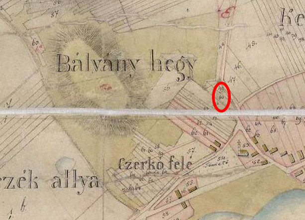
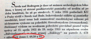
The late Füzesabony cemetery was added to literature under the name Bodrogszerdahely-Bakhegy and its exact location was unknown up until now. Should we read the Slovakian lines of Polla’s first publications (Polla 1956, 1958), it becomes apparent that the cemetery is located westwards from the Bálvány hegy, also known as Bak hegy by the locals, in parcel 478 and the gardens of houses 49, 50 and 51. The latter data can first be found in an article discussing Copper Age graves that were found in the area (Polla 1956, 640) and after that of course in the main publication of the cemetery in 1960.
.
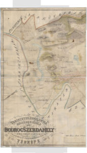
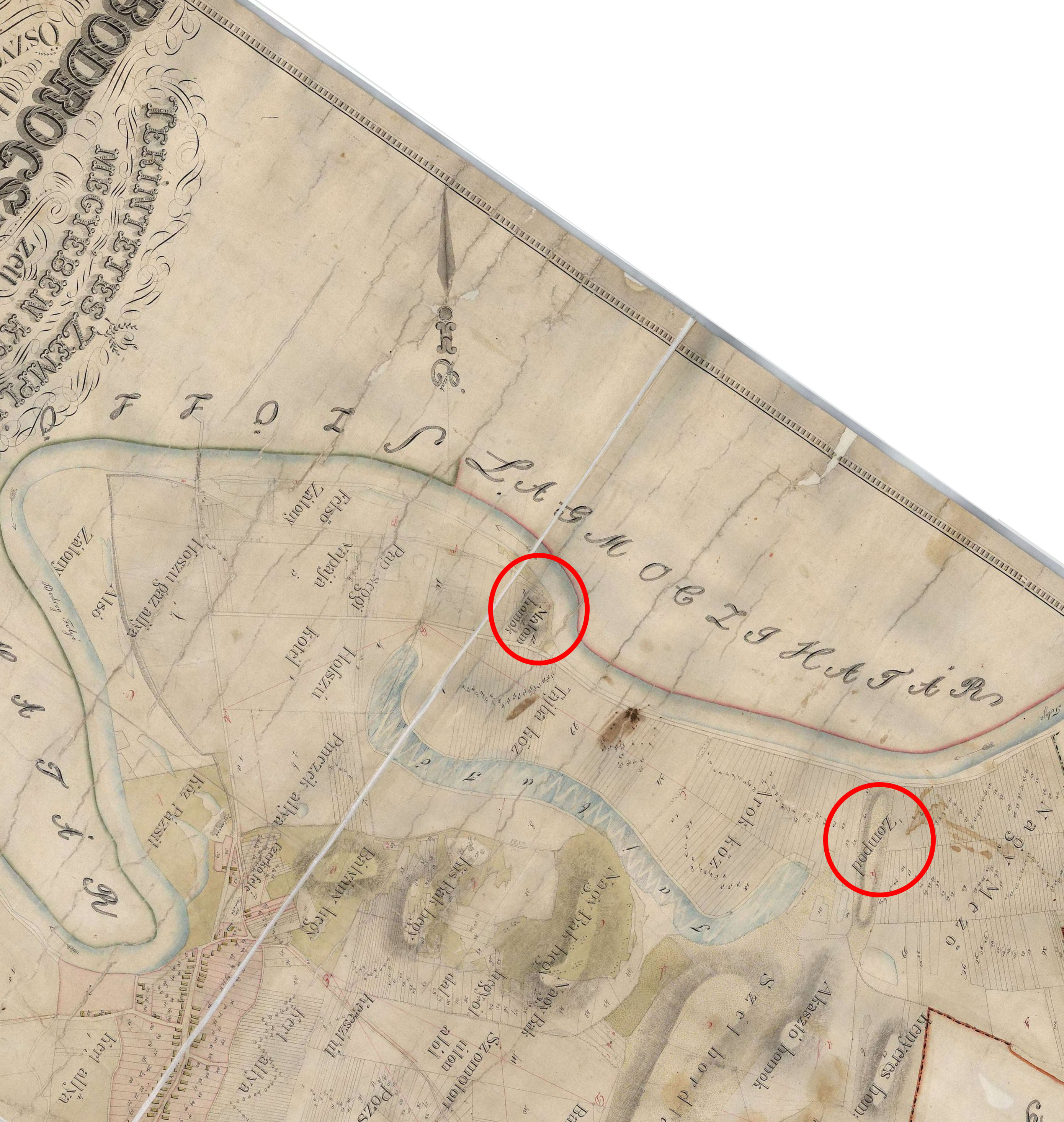
These lots can be identified precisely on the 1859 map showing the edge of Bodrogszerdahely, which can be found on the Hungaricana website under number TK 1339 (https://maps.hungaricana.hu/hu/OSZKTerkeptar/1335/?list=eyJxdWVyeSI6ICJCb2Ryb2dzemVyZGFoZWx5In0).
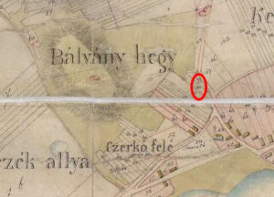
This map also provides other useful information. Three mountains can be found at Bodrogszerdahely. The westernmost is the Bálvány hegy, east of it lie the Lesser and Greater Bak hegy. The description above though specifies the area of the cemetery and ties it to the Bálvány hegy, therefore the proper name for the site should be Bodrogszerdahely-Bálvány hegy henceforward.
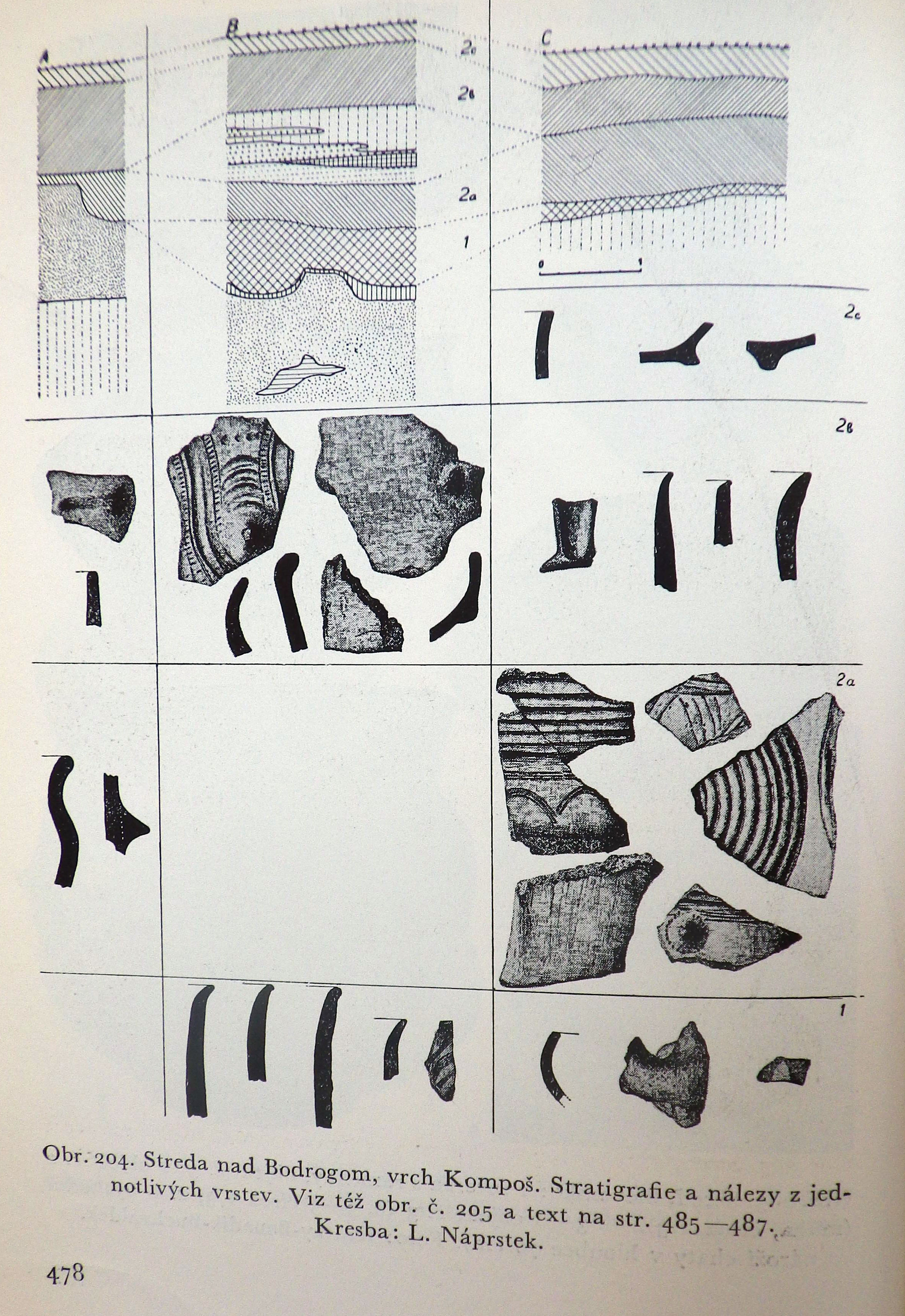
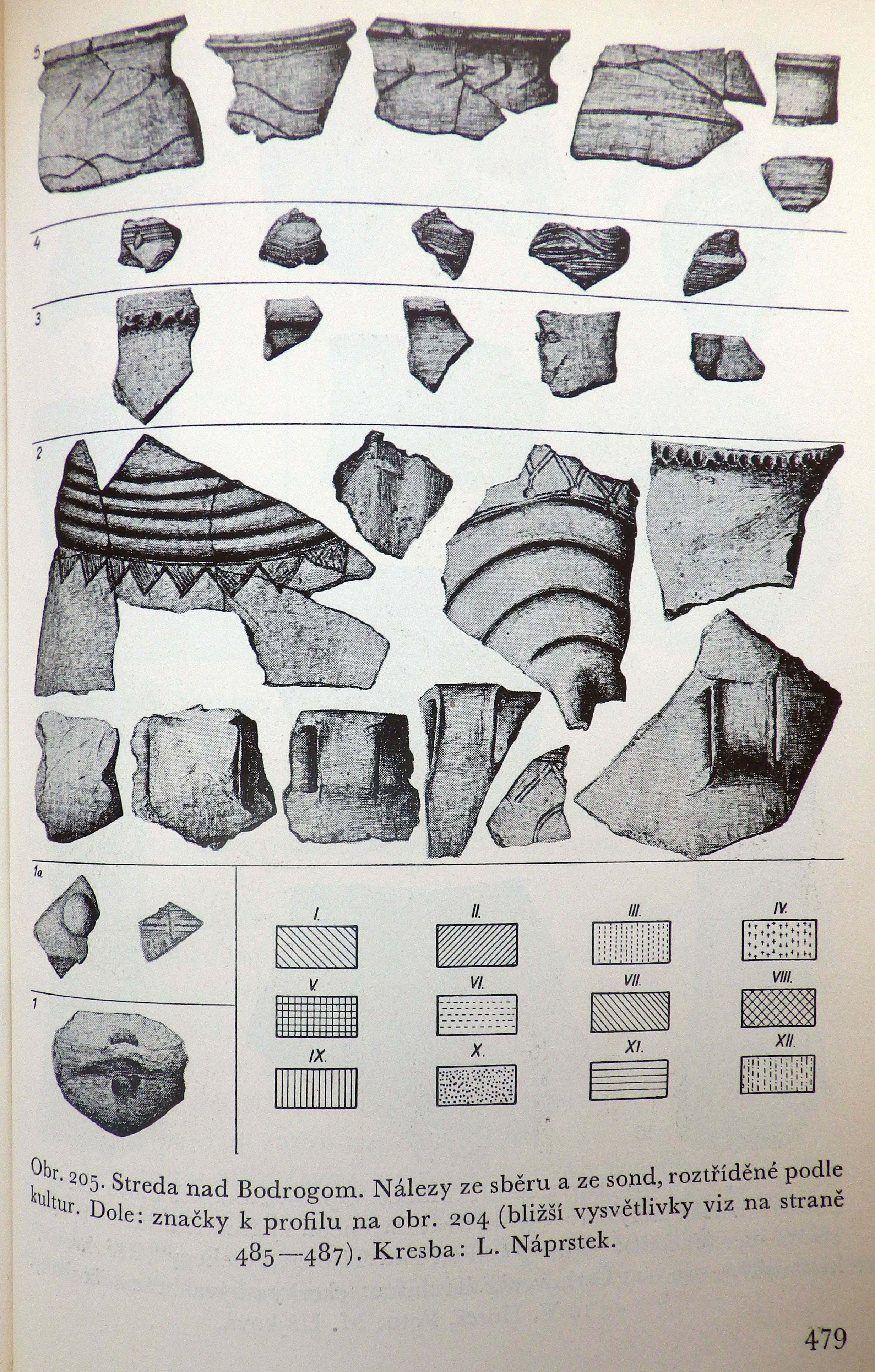
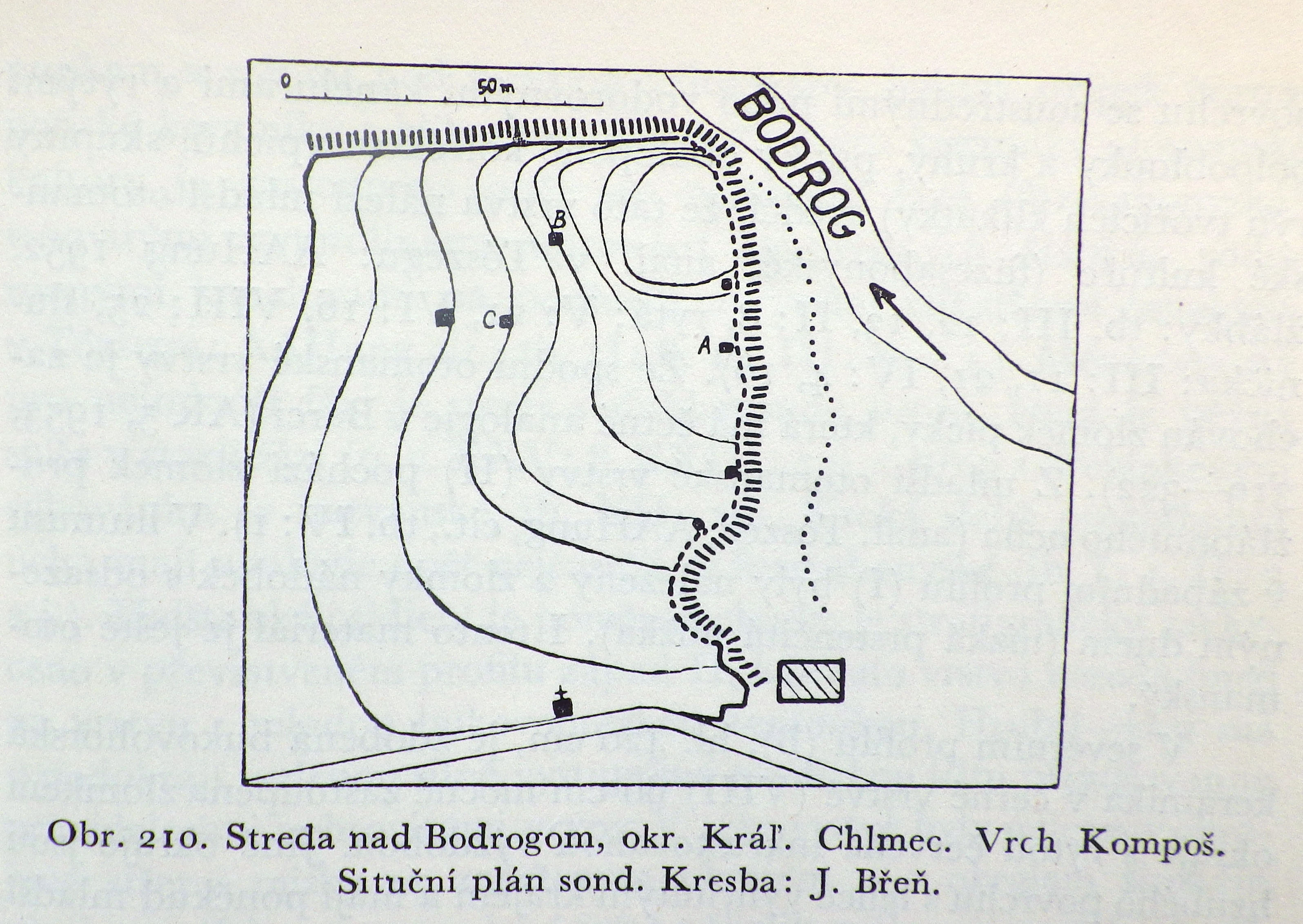
Polla writes that the settlement to which the cemetery belongs is located 1500 metres to the north, named Kompošt (Polla 1958, 511), and refers to the 1954 article of Soudský and Břeň. When describing the site north of the village, the area is named Kompoš, but it is mentioned that the site is referred to by Š. Janšák as Zombok (Janšák 1935). During the construction of the railroad they surveyed a multi-layered site on the river Bodrog’ backwater bank with three small probes. Beneath the medieval layer was one from the Iron Age, then a thick layer from the Otomani culture came to light during the excavation, under which a layer from the Neolithic was found. Based on the publication, this second last is in fact a settlement layer than can be classified as late phase Füzesabony culture.
On the aforementioned map, the border section named Zompod is a north-south facing hillside located east of the settlement close to the edge of Somotor/Szomotor; it has a significant end that connects to the river Bodrog, furthermore it is cut by railroad. This hill however neither fits the orientation nor the distance mentioned in descriptions.

Its mystery is partially solved on page 157 of Andel’s 1955 article, where three sites are mentioned at the edge of Bodrogszerdahely. Here Andel calls the Kompoš site Malomhomok. This area can be well identified based on the aforementioned and multiple other 20th century maps. The layout published by Soudský and Břeň also fits the Malomhomok area. Therefore the location of the Bálványhegy cemetery’s settlement (based on Polla) can be determined and it should be called Malomhomok to avoid confusion.
In addition, Andel mentions Zompod as a separate site as well as another one named Šibeničny kopec, meaning ‘gallows’. On the 1859 map, there is an area south of Zompod called Akasztó homok. This can be resolved by the fact that in 1935, Janšák refers to the Bak and Bálvány hegy as Akasztó domb on a map.
All in all, Andel’s three sites are:
- the Bálvány/Bak hegy, erroneously named Akasztófa/Akasztódomb
- Malomhomok, referred to as Kompoš in most places
- Zompod
Incidentally on page 484, the area of Zompot, located at the edge of Szomotor, is mentioned by Soudský a Břeň as a Hallstatt period settlement.
The situation is further complicated by the fact that literature also knows of an Otomani settlement named Bakhegy. However during the excavation of Slavic barrows, Budinský-Krička found that they were from a Bronze Age settlement layer and likened its material to that of the Nagyrév culture. On the other hand the publication table shows characteristics of early Otomani culture (Budinský-Krička 1959).
Nándor Fettich and Gyula László excavated Hungarian Conquest age graves on Bak hegy. Unfortunately the documentation of it has been lost, but based on a catalogue of Hungarian Conquest era finds, Tibor Báder placed the excavation’s location on the Bálvány hegy (Báder 1998). Once again, Bronze Age artefacts came to light during the excavation of the graves, which suggest the presence of a massive Bronze Age settlement layer. These Bronze Age finds were placed in the Hungarian National Museum and published by Tibor Kovács in 1982. This assemblage also belongs to the culture’s early phase. This means that near the late cemetery, presumably on the Bálvány hegy where the Slavic and Hungarian Conquest era graves were excavated, an early settlement can also be found, its exact location unknown.
Based on this prior information we attempted to find and identify the site on December 29, 2017.
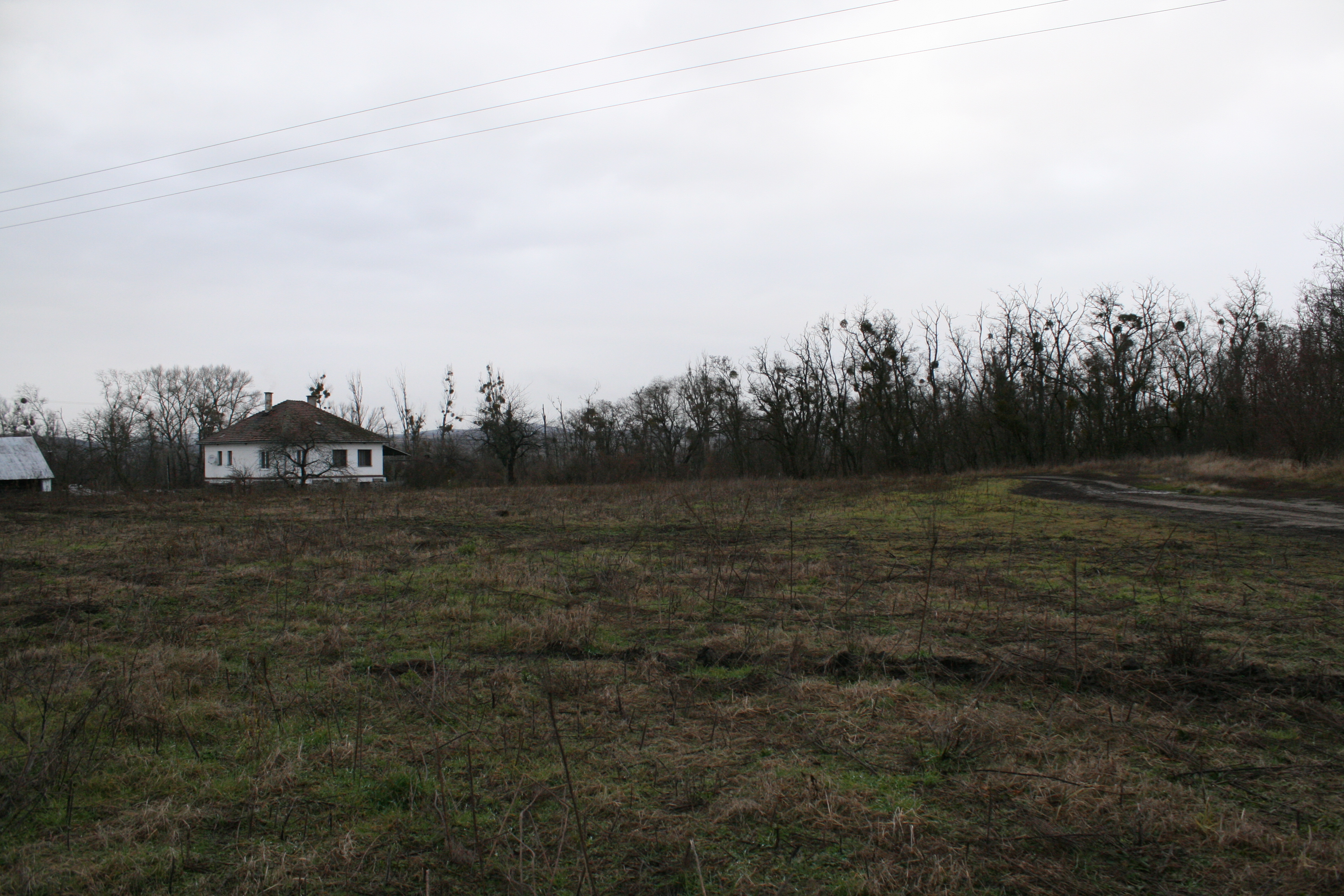
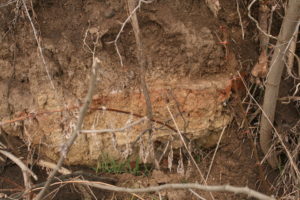
The end of the Zompod/Zompot hill is crossed by both road and railroad. We collected a vast amount of archaeological finds, mostly undecorated ceramics, on the hill next to the railroad guardhouse. The hill is partially covered with dense shrubs and a pit in the middle that hints at mining; a vertical embankment to the south shows that part of it has been levelled and mined. The southern areas keep increasing in height and we found traces hinting at trenches here. The area is definitely an archaeological site, its age later to be determined.
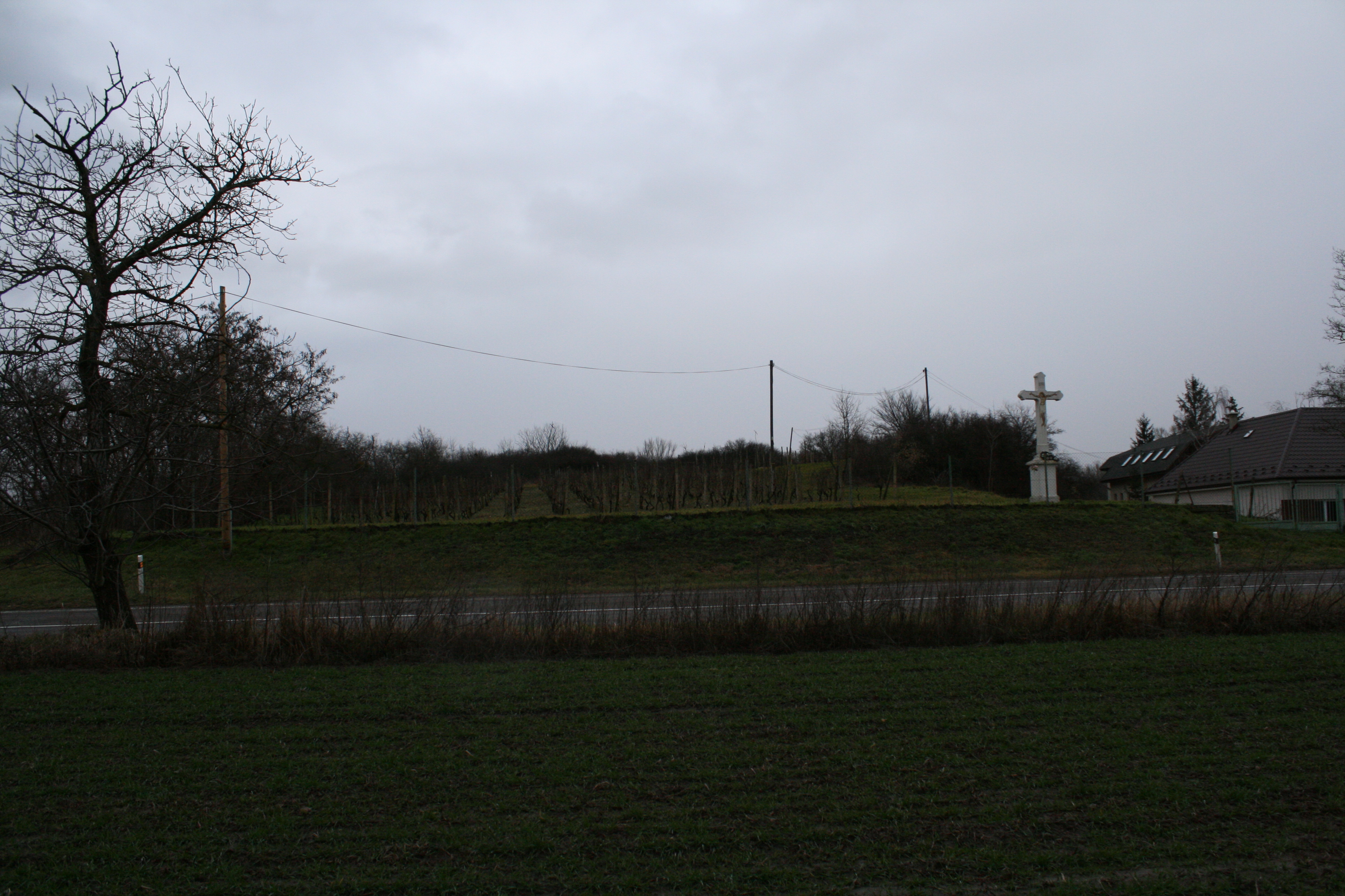
The area of Malomhomok is well identifiable, even the crucifix depicted on the 1954 map is still present by the roadside. The hillside closer to the river Bodrog is bushy and very rocky while its southern side has a vineyard on it. But the western and southern parts of former hill that were cut off by road are fields, from which we collected a large amount of finds (such as pieces of a portable heard) along with many obsidian raw materials.

The area of the Bálvány hegy cemetery has been built in with houses; its location can only be marked on map.
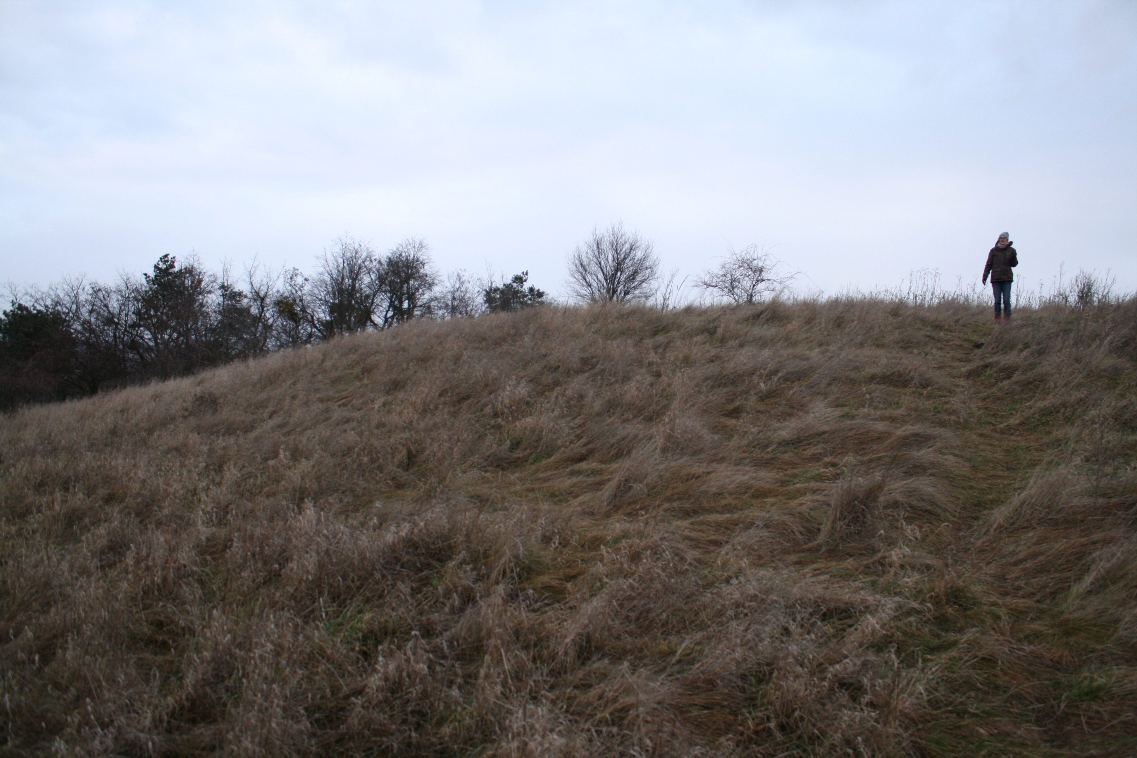
Climbing to the top of the Bálvány hegy though, we find a circular flat plateau with a diameter of 50 metres which is surrounded by a few metres wide terraced strip. The surface of it cannot be seen as the entirety of the area is covered in tall sedge grass. Every molehill on the plateau’s surface however was rich in archaeological finds. The formation of the mountaintop is verily similar to the shape and size of the early Hatvan culture settlement found at Hernádbüd (for more information, visit http://bronzkor.hu/hernadbud-vardomb/); the assemblage found is from the Bronze Age, but unfit for further identification.
Overall we identified four sites during data comparison. The location of the cemetery published by Polla is confirmed along with the settlement named Malomhomok/Kompoš, located 1500 metres north of it. There is a plateau on the top of Bálvány hegy that is certainly a result of conscious landscaping, surrounded by an artificial terrace. Based on our current knowledge this could be the location of the early Bálvány or Bak hegy settlement. The area of Zompod/Zompot is definitely a separate site as well, although its age remains uncertain.
With that in mind it is likely that Maria Novotna may have confused two settlement sites in her 1995 brief summary.
It is possible to perform additional non-invasive surveys at certain parts of the Malomhomok and Bálvány hegy areas, which we plan doing so in the future.
Bibliography:
Karol Andel: Výsledok archeologického prieskumu na zemplínsko-užskej nížine v rokoch 1953/54.Vlastivedný Sborník I. Košice 1955, 144-171
Budinský-Krička, V.: Výskum na slovanskom mohylníku v Strede nad Bodrogomr. 1957. Archeol Rozhl 11 (1959), 528-531.
Štefan Janšák: Praveké sídliská s obsidianovou industriou na vychodnom Slovensku. Bratislava 1935
Kovács Tibor: Die terminologischen und chronologischen Probleme der frühen und mittleren Bronzezeit in Ostungarn. In: Atti X. Simp. Int. Neol. Etá Bronzo in Europa. Verona 1982, 153-164.
Belo Polla Eneolitické nálezy v Strede nad Bodrogom. Archeologické Rozhledy 8, 1956, 640-643
Belo Polla: Birituálne füzesabonyské pohrebisko v Strede nad Bodrogom. Archeologické Rozhledy 10, 1958, 511-515.
Belo Polla: Birituelle Füzesabonyer Begräbnisstätte in Streda nad Bodrogom. In: Pohrebiská zo staršej doby bronzovej na Slovensku I. Bratislava 1960, 299-386.
- Soudský – J. Břeň: Archeologický Pruzkum trati družby Košice-Čierna nad Tisou v. r. 1951.ArchRozhl VI (1954) 463-490.
[post_title] => The “lost” sites of Streda nad Bodrogom/Bodrogszerdahely
[post_excerpt] =>
[post_status] => publish
[comment_status] => open
[ping_status] => open
[post_password] =>
[post_name] => bodrogszerdahely-elveszett-lelohelyei
[to_ping] =>
[pinged] =>
[post_modified] => 2018-01-24 18:34:23
[post_modified_gmt] => 2018-01-24 18:34:23
[post_content_filtered] =>
[post_parent] => 0
[guid] => http://bronzkor.hu/?p=1152
[menu_order] => 0
[post_type] => post
[post_mime_type] =>
[comment_count] => 0
[filter] => raw
[post_title_ml] => [:hu]Bodrogszerdahely "elveszett" lelőhelyei[:en]The “lost” sites of Streda nad Bodrogom/Bodrogszerdahely[:]
[post_title_langs] => Array
(
[hu] => 1
[en] => 1
)
)
[12] => WP_Post Object
(
[ID] => 1418
[post_author] => 2
[post_date] => 2017-12-20 17:43:06
[post_date_gmt] => 2017-12-20 17:43:06
[post_content] => A few sites in the Košice Basin have not been mentioned yet that I would like to briefly summarize now. I shall not discuss the sites Nižná Myšľa/Alsómislye, Várhegy, Konopiska, Alamenev and Pod zdanskym brehom, since we plan to conduct multiple surveys there during spring which I will report in due time.
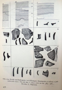
The first site, heading north from south, is Seňa/Abaújszina-Vyšný Ián. There was a rescue excavation at a multi-period site during the digging of a gas line at the terrace edge of the river Hornád’s right tributary, the Sokoliansky potok. Neolithic, early and middle Bronze Age finds and Roman Era remains came to light. Some of the six late Füzesabony culture graves came to light in superposition with Piliny culture pits (Horváthová 2011, finds see on the main picture). The location of the settlement where these burials belong to is so far unknown.
We have two pieces of data from the area of Veľká Ida/Nagyida. During a 1951 field survey north of the village at Primkynec, Otomani, Iron Age and Middle-Ages assemblages were collected in a gravel pit (Hajek 1953, 321). Literature reports the site’s complete destruction in 1977 (Lamiová-Schmiedlová-Miroššayová 1991, 174). Gašaj-Olexa 1992, Karte 1 and accordingly, Jaeger-Olexa 2014, 163 mark the site as an open settlement. Šteiner considers the site located 6 kilometres from Barca as one of its satellite settlements. The assemblage found there is classified by Šteiner as part of the post-classical phase, but he does not exclude the possibility that the settlement might have even existed during the same time as layer 2 from Barca.
Dominika Oravkinova brought my attention to a piece of unpublished data according to which Otomani finds also came to light north of the village, in the area between the castle and the Ida stream. It is questionable whether this area has any relations to Primkynec.
One interesting fact is that a Hatvan, Piliny and Roman settlement was discovered at Veľká Ida/Nagyida- Zámocké tably. During the evaluation of the animal bone material from pit 1, Z. Miklíková refers to the piece of data 1750 BC C14. This C14 data in the given territory corresponds more to the Otomani period, as it fits with the RA2 period. We know Hatvan culture sites from the RA2 period, but only from areas west of the OFK where Hatvan culture survived up until the Tumulus period.
Therefore based on literature alone, we can only consider the completely destroyed Primkynec site as part of the OFK period with certainty for now. However if it is 6 kilometres away from Barca, then based on observations at the Southern Borsod Plain, it is not a satellite but rather an individual settlement.
Two additional sites are known from the edge of the settlement Sebastovce/Zsebes. Administratively, Sebastovce falls under Košice, so these sites should have already been presented along with the ones from Košice. During the excavation of an Avar-Slavic cemetery at Lapise, two OFK settlement features came to light (Budinský-Krička 1976, 68–69; Lamiová-Schmiedlová-Miroššayová 1991, 53 and additional literature).
Even more OFK settlement features were found in the area of Kenderkert. (Lamiová-Schmiedlová-Miroššayová 1991, 52-53 and additional literature).
Bibliography:
Budinský-Krička 1976 - V. Budinský-Krička: Výskum slovansko-avarského pohrebiska a sídliska z mladšej doby bronzovej v Šebastovciach. AVANS v roku 1975, 1976, 67-69.
Gašaj/Olexa 1992 - D. Gašaj / L. Olexa: Nižná Myšľa - ein bronzezeitliches Hanselszentrum in der Ostslowakei. Wuppertal 1992.
Hájek 1953 - L. Hájek: Vzácny nález z doby bronzové v Barci u Košic. Archeologické Rozhledy 5, 1953, 319-322.
Horváthová 2011 - E. Horváthová: Pohrebisko otomanskej kultúry v Seni. Študijné zvesti AÚ SAV 49, 2011, 115-141.
Hreha/Olexa 2009 - R. Hreha/L. Olexa: Sídlisko z doby bronzovej a doby rímskej vo Veľkej Ide. AVANS 2007, 2009, 80, 81.
Jaeger/Olexa 2014 - M. Jaeger/ L. Olexa: The metallurgists from Nižná Myšľa (okr. Košice-okolie/SK) A contribution to the discussion on the metallurgy in defensive settlements of the Otomani -Füzesabony culture. Archäologisches Korrespondenzblatt 44, 2014, 163–176
Lamiová-Schmiedlová/Mirrošayová 1991 - M. Lamiová-Schmiedlová / E. Mirrošayová: Archeologická topografia - Košice. Košice 1991.
Miklíkova 2011 - Z. Miklíková: Zvyšky zvierat z doby bronzovej a rímskej zo sídliska vo Veľkej Ide. AVANS 2008/2011, 186-189.
Šteiner 2009 - P. Šteiner: Keramický inventár otomansko-füzesabonyského kultúrneho komplexu vo svetle nálezov z Barce I. Nitra 2009.
[post_title] => Archaeological sites of the Košice Basin 4: Sites that have been left out so far
[post_excerpt] =>
[post_status] => publish
[comment_status] => open
[ping_status] => open
[post_password] =>
[post_name] => a-kassai-medence-lelohelyi-4-ami-eddig-kimaradt
[to_ping] =>
[pinged] =>
[post_modified] => 2018-02-07 17:53:35
[post_modified_gmt] => 2018-02-07 17:53:35
[post_content_filtered] =>
[post_parent] => 0
[guid] => http://bronzkor.hu/?p=1418
[menu_order] => 0
[post_type] => post
[post_mime_type] =>
[comment_count] => 0
[filter] => raw
[post_title_ml] => [:hu]A kassai medence lelőhelyi 4: ami eddig kimaradt[:en]Archaeological sites of the Košice Basin 4: Sites that have been left out so far[:]
[post_title_langs] => Array
(
[hu] => 1
[en] => 1
)
)
[13] => WP_Post Object
(
[ID] => 1408
[post_author] => 2
[post_date] => 2017-12-12 15:40:48
[post_date_gmt] => 2017-12-12 15:40:48
[post_content] => Apart from the fortified settlements of Košice-Barca/Kassa-Bárca, Nad Begányijo mlynom and Nižná Myšľa/Alsómislye, Várhegy there is another lesser-known settlement in the Košice Basin with a similar structure: Rozhanovce/Rozgony, poloha Plebanské II. The settlement lies on a terrace at the meeting of the Torysa/Tarca and Olšianský streams. The site was excavated between 1978 and 1983. Based on published data I found that the area of the Bronze Age settlement has not been fully excavated yet, therefore making it ideal for non-destructive research and comparison with the previously excavated area. However I was left sorely disappointed. Today, a plant nursery is situated over the location of the Bronze Age settlement, which meant that it was fully transformed, with no sign of the ditch or any other observable microtopographic features hinting at the former surface. The central part of the Bronze Age settlement has been completely destroyed.
So far there have been two publications discussing the settlement’s inner structure (Gašaj 1983; 2002). Based on those we know that the Bronze Age settlement was protected from two sides by a ditch and rampart. The ditch was 15-16 metres wide and 4 metres deep. The rampart was 8 metres wide at the base; its outer and inner sides were reinforced by palisade walls. The diameter of the thusly made protected area was 40 metres. Two main settlement horizons were observed here, similar to Košice-Barca I and Nižá Mišľa. We only know of a few houses from the earlier horizon, the rampart was not present at that time. After the houses of this period were destroyed by fire, the ramparts were partially built atop them and the houses of the younger period were constructed, of which 11 were excavated. In this period the houses were organized into streets, following the line of the fortification. The houses of both settlement periods were single-room (with 4x4.5 metres of floor space), daub-walled, plastered floored buildings with a fireplace.
The Rozhanovce settlement can be dated into the classical phase of OFK, the younger layer being as old as layer I/3, while the older layer partially matching layer II of the Barca settlement.
The settlement was first described by Budinský-Krička (Budinský-Krička 1976; 1977) and it was also mentioned later by Jurecko (Jurecko 1980), however both refer to it as Rozhanovce-Hôrka. This means that the two place names refer to the same settlement. In these early reports Bükk culture, Neolithic painted pottery, Copper/Bronze Age transitional and Post-Bronze Age uses are all mentioned when describing the area; OFK dating was not obvious at that time.
However the descriptions also mention Bronze Age finds located on both banks of the Olšianský stream. This area is called Pod silaše, situated at the edge of Košické Oľšany/Kassaolcsvár. In 1995, Novotná stated that it was the Olšianský stream that likely separated the fortified part of settlement from its unfortified portion. Another settlement is mentioned in the nearby swampy area. We also know from Novotná that approximately a quarter of the fortified area had been excavated. During our fall survey the area at Košické Oľšany was covered in waist high weeds. After a clean-up the area may be suitable for geophysical survey.
Barca and Rozhanovce are 8 kilometres apart each other; the distance between Barca and Nižná Myšľa is 10 kilometres, and 12 kilometres in the case of Rozhanovce and Nižná Myšľa. Counting with an average 4 km/h walking speed, if Bronze Age people set out in the morning, they could visit their neighbours by lunchtime. Not to mention the possibility of sailing down the Torysa/Tarca.
Signs of craftsmanship are known from all three settlements, and based on their fortifications we can evaluate them as central settlements. Their inner structures, the size of their houses and their assemblages are identical and they existed in the same horizon chronologically, meaning they were likely settlements of equal rank within the Košice Basin microregion.
We can observe the duality at the Rozhanovce—Košické Oľšany settlement group that I highlighted as a key point at the beginning of the research: is there a so-called outer settlement of these “fortified” settlements, and if so, what is the relation between them? So far we did not find a site from which any new observations could be added to the answers for this question.
But let’s not get impatient!
Literature:
Budinský-Krička 1976b - V. Budinský-Krička: Sídlisko z prelomu eneolitu a doby bronzovej v Rozhanovciach a Košických Olšanoch. AVANS v roku 1975, 1976, 64-65.
Budinský-Krička 1977 - V. Budinský-Krička: Nálezy z prieskumu na východnom Slovensku. AVANS v roku 1976, 1977, 65-81.
Gašaj 1983 - D. Gašaj: Výsledky záchranného výskumu opevnenej osady otomanskej kultúry v Rozhanovciach. Archeologické Rozhledy 35, 1983, 130-137.
Gašaj 2002a - D. Gašaj: Fortified settlement at Rozhanovce. In: Między Mykenami a Bałtykiem - Kultura Otomani-Füzesabony. Krosno-Warszawa 2002, 35-37.
Novotná 1995 – M. Novotná: Befestigte Siedlungen der Otomani-Kultur in der Slowakei. In: Settlement patterns between the Alps and the Black see 5th to 2th milennium B.C. Verona-Lazice 1992, Sezione Scienze dell uomo No. 4, 1995, 141-145.
[post_title] => Archaeological sites of the Košice Basin 3: Rozhanovce, Plebanské Flur II (Hôrka)
[post_excerpt] =>
[post_status] => publish
[comment_status] => open
[ping_status] => open
[post_password] =>
[post_name] => english-kassai-medence-lelohelyei-3-rozhanovce-plebanske-flur-ii-horka
[to_ping] =>
[pinged] =>
[post_modified] => 2018-02-06 15:43:42
[post_modified_gmt] => 2018-02-06 15:43:42
[post_content_filtered] =>
[post_parent] => 0
[guid] => http://bronzkor.hu/?p=1408
[menu_order] => 0
[post_type] => post
[post_mime_type] =>
[comment_count] => 0
[filter] => raw
[post_title_ml] => [:hu]Kassai medence lelőhelyei 3: Rozhanovce, Plebanské Flur II (Hôrka)[:en]Archaeological sites of the Košice Basin 3: Rozhanovce, Plebanské Flur II (Hôrka)[:]
[post_title_langs] => Array
(
[hu] => 1
[en] => 1
)
)
[14] => WP_Post Object
(
[ID] => 1366
[post_author] => 2
[post_date] => 2017-12-10 19:06:46
[post_date_gmt] => 2017-12-10 19:06:46
[post_content] => The compilation of archaeological sites in Košice is one of the lower priority tasks, given that a topographic volume has already been made for the Košice–okolie District (Lamiová-Schmiedlová/Mirrošayová 1991), however it can still be full of surprises.
One of the most well-known sites in Bronze Age literature is the fortified settlement of Košice-Barca/Kassa-Bárca. Barca used to be a separate village, but by now it became a part of Košice. The name of the archaeological site: Begányi (Begahner)-Mühle/malom, or Nad Begányijo mlynom in Slovak. The entire area of the Bronze Age settlement is now completely built in with family houses. The former settlement is unrecognisable on the surface both in terms of spatial form and microreliefs. I mention this because there is a major recess in line of the former Bronze Age ditch at Szihalom, which is well noticeable even on the paved road network.
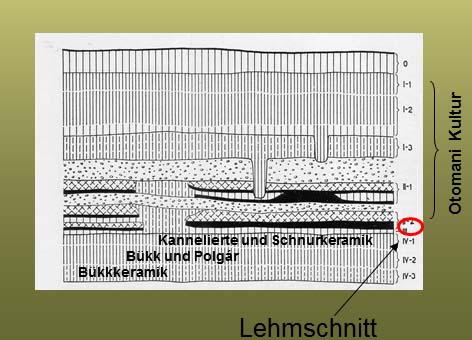
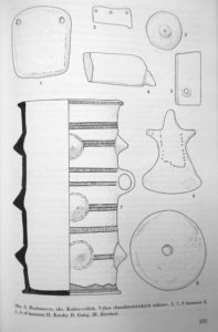
The Barca site can be found on the southern bank of the Myslavký stream. The surface of its plateau, rising 12 metres above the stream, was fortified on the western and southern sides with a ditch and walls. The northern and eastern sides were bordered by the line of the natural embankment. In 1936, J. Teplý, former owner of the area conducted excavations here. Ferenc Tompa also excavated the site in 1941, but a systematic excavation on the entirety of the area only occurred between 1951 and 1954, under the lead of F. Prošek, L. Hájek and J. Kabát (Kabát 1955; Hájek 1953; 1954; 1957; 1959; 1961).
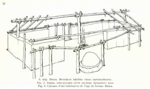
The documentation of Tompa’s excavation was destroyed but László Varga, having seen the document in 1942, wrote a short summary of its results and also created a house reconstruction (Vargha 1955). J Pástor also performed excavations here in 1949.
The area was inhabited not only in the Bronze Age. The order of the layers is the following:
Middle Ages
La Tène Period
Layers I-II.: Bronze Age
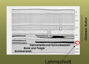
Layer III.: Certain publications describe it as a levelled clay layer that serves as the foundation for the Bronze Age settlement (Bader 1998, 67), others describe it as a grey clay layer and evaluate it as part of the Otomani settlement based on its spiralled knob and textile decorated ceramics. In a recent monograph from P. Šteiner (2009) it was valued as a levelling layer.
Layer IV/1: Baden Culture
Layer IV/2?: Mixed Bükk and Tiszapolgár type materials
IV/1 Bükk-Culture
Mesolithic
Palaeolithic features sunk in subsoil
Layer II. has to be divided to two sub-phases based on statigraphic observations. This is the first fortified phase of the settlement. The fortification is wood-dirt construction, followed by a ditch on the outside. The exterior of the fortification was covered by walls daubed with clay. The fortification was 4 metres thick at the base and 2.85 metre tall. In an earlier phase there was a pathway paved with rocks, located on the inner side of the fortification, with houses adjusting to its route. Houses in the southern and northern areas had two rooms, with single room houses between them. This rock-paved route was not in use in the more recent layer. Three room houses were built at the southern wall, in lieu of the two-room houses and four new buildings facing east-west were also constructed. After a burned house horizon the settlement was rebuilt, this is what we refer to as Layer I. The previous ditch outside of the wall was buried and wider 4.50 metre high wall was built, further heightened by a palisade. The newer, 10 metre wide ditch was dug 7 metres outwards of it. The new wall was built not only on the old ditch, but also on the foundation of the old houses and it also lacked an inner wooden construction. Layer I. was 90 cm thick and divided into 3 sublayers; it had no trace of any regularly made road network. Traces of buildings are indicated by stone construction and postholes, without any noticeable clay floor. According to Točik, two-story houses could have been present in the settlement this period. The uppermost layer was dated by its Bodrogszerdahely type ceramics, based on that it can be placed in the latest, Koszider phase of the Füzesabony culture.
Outside of the fortified area a so-called “Vorburg” or outer settlement part existed, defined by it pits.
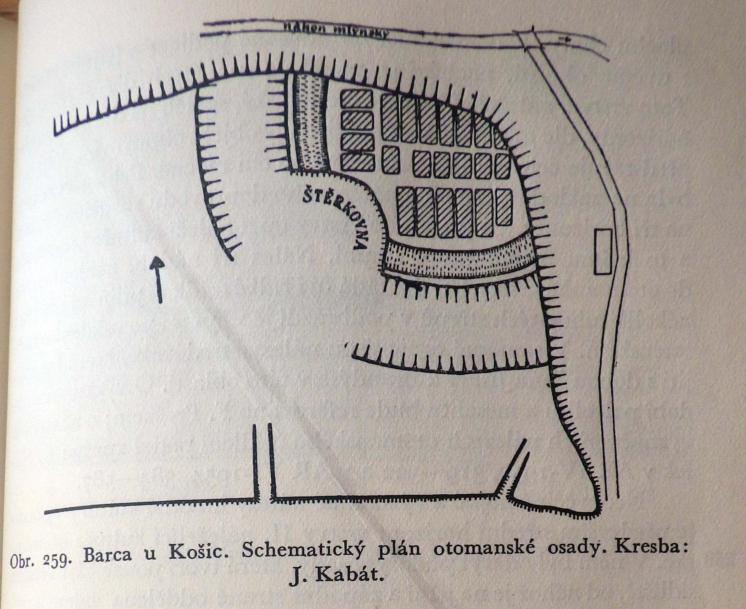
The size of the fortified area was 50x50 m.
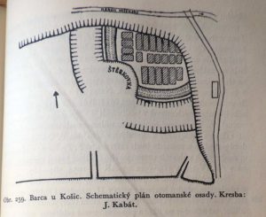
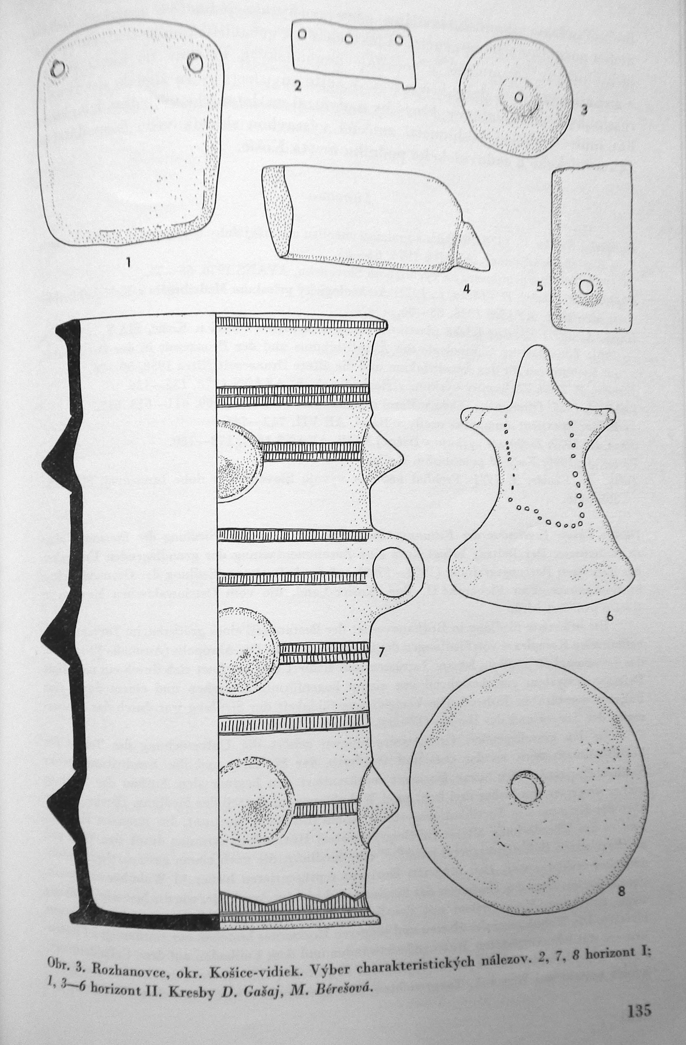
The only ground plan in literature for a long time was the one published by J. Kabát (Kabát 1955, obr. 259). In his 1994 article, Točik separates the houses found on the Kabát ground plan by phases, creating the two sub-phases of Layer II., the description above matches this.
Based on that, the ground plan (Fig.3) published in the catalogue Między a Mykenami a Baltykiem (Gancarski 2002) also pictures things erroneously by mixing the elements of certain phases.
The 2009 work of P. Šteiner shows a detailed picture on ground plan development:
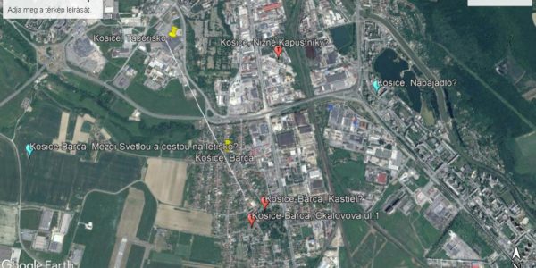
— Located 700 metres south of the Bronze Age Barca settlement, we know about additional Füzesabony culture graves within the settlement of Barca from the areas Košice-Barca – Kastiel. Topographic Vol. no.: 1/7.
— Kosice-Barca, Čkalovova ul.1. Two Bronze Age ceramic sherds came to light here while laying down the electric line. Based on oral information from D. Gašaj, this area is also a burial site. Topographic Vol. no.: 1/3.
— Remains hinting at the presence of a settlement were found at the site Kosice-Barca, Mezdi Svetlou a cestou na letisko. Vol. no.: 1/9.
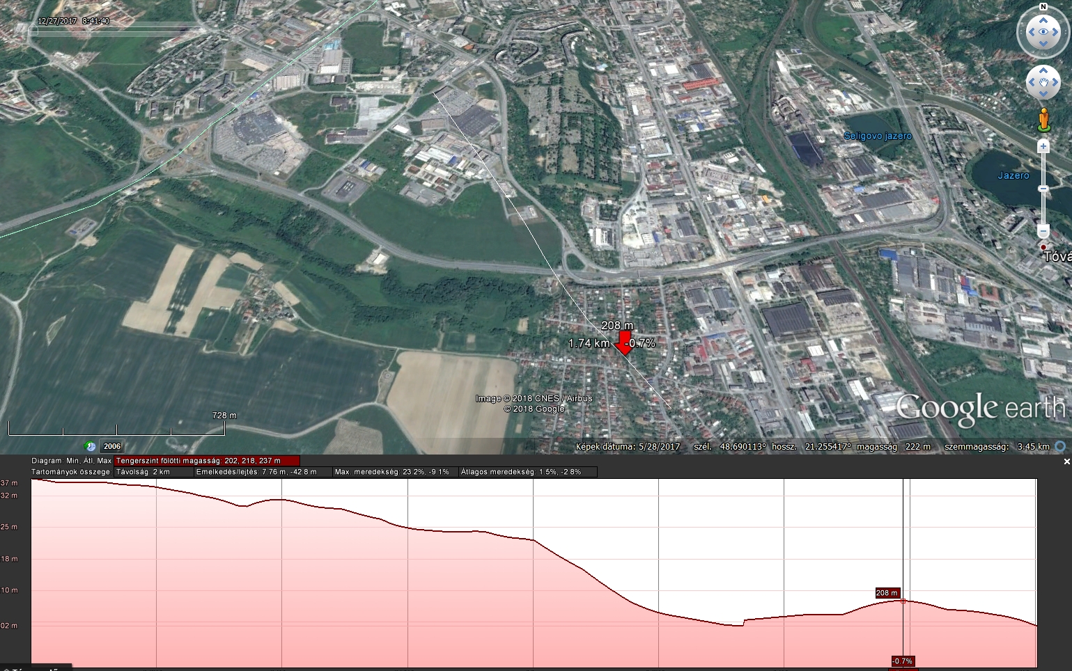
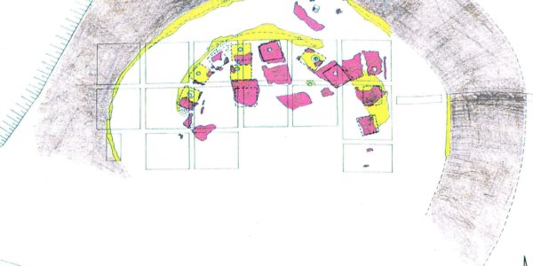
The real surprise for me was the 2001 newscast of L. Kaminská reporting on a new Füzesabony culture settlement located on the plateau of the northern bank of the Myslavský stream, in the Táborisko parcel. During the emergency excavation before the construction of a Cassovia shopping centre, 41 Otomani settlement features came to light, one of which, according to the digger, being the work pit used for creating handcrafted items. The assemblage of the excavation is currently getting prepared for publication. Based on L. Kaminská’s gracious recount, the area made available for them had its humus layer removed. However at the edge of the surface, where less of the soil was cleared, L. Kaminská documented large, burnt spots of daub via photographs, which can be evaluated as remains of surface houses. This means that not only pits were present on the Táborisko plateau, but it was also a settlement with houses similar to those found at Barca in terms of age. Today the entirety of the plateau is built in with shops and parking areas. Füzesabony culture finds came to light here during the excavation of other areas as well. No signs of a ditch or other fortifications were found throughout the excavation. However based on the typology of the finds, there had to be a period where both settlements were standing. The Táborisko plateau is higher than the one in Barca, the two sites are clearly visible from each other. According to L. Kaminská, there is a spring at the Táborisko plateau that still flows today and it is led to the valley underground. Therefore this plateau was just as ideal of a place to settle as the one facing it, and perhaps even offering more comfort due to its southern exposure. This image of double settlements is brand new in relation to what we had known previously, I cannot recall other examples from elsewhere yet. Since both areas are completely covered, we do not have the opportunity to conduct further research and answer any questions that may arise.
Therefore we cannot clearly evaluate the two settlements as cluster types (Duffy 2014, 203-206). We do not know whether the groups living in them were a single community or defined themselves as separate groups. If the latter was the case, was there any kind of dominant or subordinate relation between them?
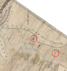
We marked the locations of the Cassovia shopping centre and the fortified settlement of Barca on the print below. Their altitude relations are clearly visible. A recess can be seen in front of the shopping centre on a relief, at the edge of the embankment. It seems obvious to consider this as a Bronze Age ditch, the other side of which the excavation led by L. Kaminská was performed, meaning that the pit area and the inner, ditch-surrounded area were both destroyed by then. This however, is only an educated guess without any evidence to support it, and it is unlikely that it will ever receive any.
We know of two additional Füzesabony culture sites in the vicinity of the two settlements’ area.
— In the cemetery of Kosice, Nizné Kapustníky, J. Pástor uncovered 163 burials from the Košťany group and 17 Otomani culture burials (Pástor 1969a; 1969b, 1970).
— In 1976 at Kosice, Napájadlo, finds from the Koszider phase of the Füzesabony culture came to light from the layer of a profile (Čaplovič-Gašaj-Olexa 1978, 63-64).
All known sites from the inner city of Košice have been built in by now, which regrettably makes the clarification of their relations to each other impossible.
Their topographic relations however define a small circle which was intensively inhabited during the Bronze Age. Due to this, in the case of sites from the same age – something that I currently cannot precisely evaluate – we can assign a relatively tight living space for the Bronze Age with one or perhaps more independent communities. Given the small area, I prefer to view their data as multifunctional living spaces for the same cohesive community, but this is an admittedly subjective take on my part.
Irodalom:
Bader 1998 - T. Bader: Bemerkungen zur Bronzezeit im Karpatenbecken Otomani/Füzesabony-Komplex. Überblick und Fragestellung. Jahresschrift für Mitteldeutsche Vorgeschichte 80, 1998, 43-108.
Čaplovič/Gašaj/Olexa 1978 - D. Čaplovič / D. Gašaj / L. Olexa: Archeologické prieskumy na stavbách socializmu na východnom Slovensku. AVANS v roku 1977, 1978, 62-70.
Duffy 2014 -
Paul R. Duffy Complexity and Autonomy in Bronze Age Europe: Assessing Cultural Developments in Eastern Hungary. Archaeolingua Alapítvány, Budapest, 2014
Gancarski 2002 – J. Gancarski (ed.): Między Mykenami a Bałtykiem - Kultura Otomani-Füzesabony. Krosno-Warszawa 2002,
Hájek 1953 - L. Hájek: Vzácny nález z doby bronzové v Barci u Košic. Archeologické Rozhledy 5, 1953, 319-322.
Hájek 1954 - L. Hájek: Zlatý poklad v Barci u Košic. Archeologické Rozhledy 6, 1954, 584-587.
Hájek 1957 - L. Hájek: Hlinĕné lidské plastiky z doby bronzové V Barci u Košic. Tonplastiken menschlicher Figuren aus der Bronzezeit in Barca und Košice. Slovenská Arcaeológia 5, 1957, 323-338.
Hájek 1959 - L. Hájek: Kostĕná industrie otomanské kultury z Barce. Knochenindustrie der Otomani-Kultur in Barca. Slovenská Arcaeológia 7, 1959, 285-300.
Hájek 1961 - Hájek, L.: Zur relativen Chronologie des Äneolithikums und der Bronzezeit in der Ostslowakei. In: Komission für das Äneolithikum und die ältere Bronzezeit. Nitra 1958. Bratislava 1961, 59-76.
Kabát 1955 - J. Kabát: Opevnění otomanské osady v Barci. Archeologické Rozhledy 7, 1955, 594-617, 742-746.
Kaminská 2001 - Ľ. Kaminská: Záchranné výskumy v Košiciach. AVANS v roku 2000, 2001, 96-97.
Lamiová-Schmiedlová/Mirrošayová 1991 - M. Lamiová-Schmiedlová / E. Mirrošayová: Archeologická topografia - Košice. Košice 1991.
Šteiner 2009 - P. Šteiner: Keramický inventár otomansko-füzesabonyského kultúrneho komplexu vo svetle nálezov z Barce I. Nitra 2009.
Pástor 1969a - J. Pástor: Košické pohrebisko. Košice 1969.
Pástor 1969b - J. Pástor: Príspevok k pohrebnému rítu na pohrebisku v Košiciach. Historica Carpatica 1, 1969, 167-200.
Pástor 1970 - J. Pástor: Výskum Východoslovenského múzea v rokoch 1965-66. Nové Obzory 12, 1970, 211-259.
Točik 1994 - A Točik: Poznámky k problematike opevneného sídliska Otomanskej kultúry v Barci pri Košiciach. – Bemerkungen zur Problematik der befestigten Siedlung der Otomai-kultur in Barca bei Košice. Studijné Zvesti AUSAV 30 (1994) 59-65.
Vargha 1955 – Vargha L.: A barcai bronzkori lakóház. Bronzezeitliches Wohnhaus von Barca Archaeológiai Értesítő 82 (1955) 48-56.
[post_title] => Sites in the Košice Basin 2: Košice-Barca, Košice-Táborisko and all around it
[post_excerpt] =>
[post_status] => publish
[comment_status] => open
[ping_status] => open
[post_password] =>
[post_name] => kassai-medence-lelohelyei-2-kosice-barca-es-kosice-taborisko-es-ami-korulottuk-van
[to_ping] =>
[pinged] =>
[post_modified] => 2018-01-28 15:38:07
[post_modified_gmt] => 2018-01-28 15:38:07
[post_content_filtered] =>
[post_parent] => 0
[guid] => http://bronzkor.hu/?p=1366
[menu_order] => 0
[post_type] => post
[post_mime_type] =>
[comment_count] => 0
[filter] => raw
[post_title_ml] => [:hu]Kassai medence lelőhelyei 2: Košice-Bárca és Košice-Táborisko és ami körülöttük van[:en]Sites in the Košice Basin 2: Košice-Barca, Košice-Táborisko and all around it[:]
[post_title_langs] => Array
(
[hu] => 1
[en] => 1
)
)
)
[post_count] => 15
[current_post] => -1
[in_the_loop] =>
[post] => WP_Post Object
(
[ID] => 1461
[post_author] => 2
[post_date] => 2018-08-26 12:24:10
[post_date_gmt] => 2018-08-26 12:24:10
[post_content] =>
Sorry, this entry is only available in Hungarian.
[post_title] => (Magyar) Megjelent a BORBAS projekt 2012-2017 évi kutatásait bemutató könyvünk
[post_excerpt] =>
[post_status] => publish
[comment_status] => open
[ping_status] => open
[post_password] =>
[post_name] => megjelent-a-borbas-projekt-2012-2017-evi-kutatasait-bemutato-projekt
[to_ping] =>
[pinged] =>
[post_modified] => 2018-08-26 12:33:39
[post_modified_gmt] => 2018-08-26 12:33:39
[post_content_filtered] =>
[post_parent] => 0
[guid] => http://bronzkor.hu/?p=1461
[menu_order] => 0
[post_type] => post
[post_mime_type] =>
[comment_count] => 0
[filter] => raw
[post_title_ml] => [:hu]Megjelent a BORBAS projekt 2012-2017 évi kutatásait bemutató könyvünk[:]
[post_title_langs] => Array
(
[hu] => 1
)
)
[comment_count] => 0
[current_comment] => -1
[found_posts] => 157
[max_num_pages] => 11
[max_num_comment_pages] => 0
[is_single] =>
[is_preview] =>
[is_page] =>
[is_archive] =>
[is_date] =>
[is_year] =>
[is_month] =>
[is_day] =>
[is_time] =>
[is_author] =>
[is_category] =>
[is_tag] =>
[is_tax] =>
[is_search] =>
[is_feed] =>
[is_comment_feed] =>
[is_trackback] =>
[is_home] => 1
[is_404] =>
[is_embed] =>
[is_paged] => 1
[is_admin] =>
[is_attachment] =>
[is_singular] =>
[is_robots] =>
[is_posts_page] =>
[is_post_type_archive] =>
[query_vars_hash:WP_Query:private] => 9a9323085b66c9e34dab109c4af5ba0d
[query_vars_changed:WP_Query:private] => 1
[thumbnails_cached] =>
[stopwords:WP_Query:private] =>
[compat_fields:WP_Query:private] => Array
(
[0] => query_vars_hash
[1] => query_vars_changed
)
[compat_methods:WP_Query:private] => Array
(
[0] => init_query_flags
[1] => parse_tax_query
)
[allow_query_attachment_by_filename:protected] =>
)